You are here: Home > Network List > IU - Global Seismograph Network (GSN - IRIS/USGS) Stations List
> Station GRFO Grafenberg, Germany > Earthquake Result Viewer
GRFO Grafenberg, Germany - Earthquake Result Viewer
| Earthquake location: |
Southern India |
| Earthquake latitude/longitude: |
23.4/70.2 |
| Earthquake time(UTC): |
2001/01/26 (026) 03:16:40 GMT |
| Earthquake Depth: |
16 km |
| Earthquake Magnitude: |
6.9 MB, 8.0 MS, 7.7 MW, 7.7 ME |
| Earthquake Catalog/Contributor: |
WHDF/NEIC |
|
| Network: |
IU Global Seismograph Network (GSN - IRIS/USGS) |
| Station: |
GRFO Grafenberg, Germany |
| Lat/Lon: |
49.69 N/11.22 E |
| Elevation: |
425 m |
|
| Distance: |
52.6 deg |
| Az: |
315.492 deg |
| Baz: |
97.452 deg |
| Ray Param: |
0.06665548 |
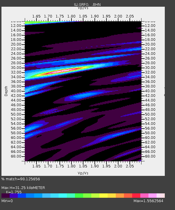
| Estimated Moho Depth: |
31.25 km |
| Estimated Crust Vp/Vs: |
1.75 |
| Assumed Crust Vp: |
6.182 km/s |
| Estimated Crust Vs: |
3.523 km/s |
| Estimated Crust Poisson's Ratio: |
0.26 |
|
| Radial Match: |
98.125656 % |
| Radial Bump: |
400 |
| Transverse Match: |
89.22765 % |
| Transverse Bump: |
400 |
| SOD ConfigId: |
3744 |
| Insert Time: |
2010-03-02 02:26:41.366 +0000 |
| GWidth: |
2.5 |
| Max Bumps: |
400 |
| Tol: |
0.001 |
|
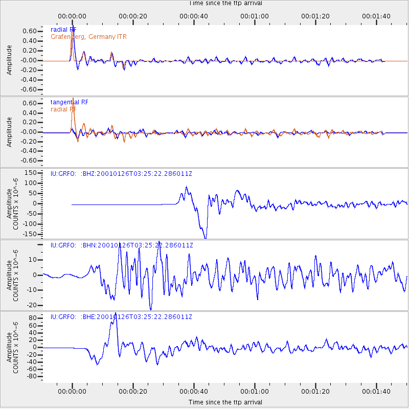
Signal To Noise
| Channel | StoN | STA | LTA |
| IU:GRFO: :BHN:20010126T03:25:22.286011Z | 0.91740906 | 7.825863E-7 | 8.530397E-7 |
| IU:GRFO: :BHE:20010126T03:25:22.286011Z | 4.024848 | 1.3441988E-6 | 3.3397504E-7 |
| IU:GRFO: :BHZ:20010126T03:25:22.286011Z | 8.05828 | 3.017086E-6 | 3.744082E-7 |
| Arrivals |
| Ps | 4.0 SECOND |
| PpPs | 13 SECOND |
| PsPs/PpSs | 17 SECOND |


