You are here: Home > Network List > TA - USArray Transportable Network (new EarthScope stations) Stations List
> Station P57A Homestead Farm, Martinsburg, WV, USA > Earthquake Result Viewer
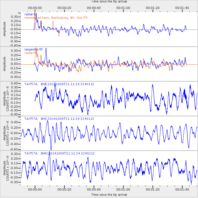
P57A Homestead Farm, Martinsburg, WV, USA - Earthquake Result Viewer
*The percent match for this event was below the threshold and hence no stack was calculated.
| Earthquake location: |
Easter Island Region |
| Earthquake latitude/longitude: |
-32.0/-111.1 |
| Earthquake time(UTC): |
2014/10/09 (282) 21:00:00 GMT |
| Earthquake Depth: |
10 km |
| Earthquake Magnitude: |
5.7 MWW, 5.6 MWC |
| Earthquake Catalog/Contributor: |
NEIC PDE/NEIC COMCAT |
|
| Network: |
TA USArray Transportable Network (new EarthScope stations) |
| Station: |
P57A Homestead Farm, Martinsburg, WV, USA |
| Lat/Lon: |
39.48 N/78.01 W |
| Elevation: |
191 m |
|
| Distance: |
77.5 deg |
| Az: |
25.672 deg |
| Baz: |
208.403 deg |
| Ray Param: |
$rayparam |
*The percent match for this event was below the threshold and hence was not used in the summary stack. |
|
| Radial Match: |
62.591805 % |
| Radial Bump: |
400 |
| Transverse Match: |
34.215687 % |
| Transverse Bump: |
400 |
| SOD ConfigId: |
803114 |
| Insert Time: |
2014-10-27 00:02:25.321 +0000 |
| GWidth: |
2.5 |
| Max Bumps: |
400 |
| Tol: |
0.001 |
|
Signal To Noise
| Channel | StoN | STA | LTA |
| TA:P57A: :BHZ:20141009T21:11:24.324011Z | 1.3068181 | 1.989234E-7 | 1.5221966E-7 |
| TA:P57A: :BHN:20141009T21:11:24.324011Z | 0.57214266 | 7.248395E-8 | 1.2668859E-7 |
| TA:P57A: :BHE:20141009T21:11:24.324011Z | 1.5683903 | 2.1101724E-7 | 1.3454384E-7 |
| Arrivals |
| Ps | |
| PpPs | |
| PsPs/PpSs | |


