You are here: Home > Network List > TA - USArray Transportable Network (new EarthScope stations) Stations List
> Station T53A Wise, VA, USA > Earthquake Result Viewer
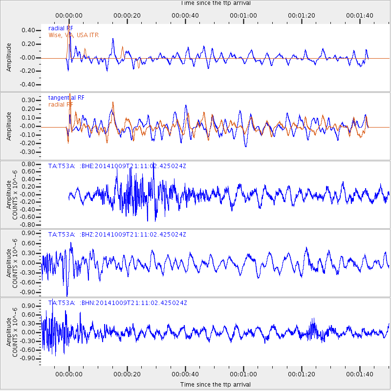
T53A Wise, VA, USA - Earthquake Result Viewer
*The percent match for this event was below the threshold and hence no stack was calculated.
| Earthquake location: |
Easter Island Region |
| Earthquake latitude/longitude: |
-32.0/-111.1 |
| Earthquake time(UTC): |
2014/10/09 (282) 21:00:00 GMT |
| Earthquake Depth: |
10 km |
| Earthquake Magnitude: |
5.7 MWW, 5.6 MWC |
| Earthquake Catalog/Contributor: |
NEIC PDE/NEIC COMCAT |
|
| Network: |
TA USArray Transportable Network (new EarthScope stations) |
| Station: |
T53A Wise, VA, USA |
| Lat/Lon: |
36.98 N/82.54 W |
| Elevation: |
818 m |
|
| Distance: |
73.6 deg |
| Az: |
23.548 deg |
| Baz: |
205.084 deg |
| Ray Param: |
$rayparam |
*The percent match for this event was below the threshold and hence was not used in the summary stack. |
|
| Radial Match: |
56.34609 % |
| Radial Bump: |
400 |
| Transverse Match: |
45.227276 % |
| Transverse Bump: |
400 |
| SOD ConfigId: |
803114 |
| Insert Time: |
2014-10-27 00:03:05.960 +0000 |
| GWidth: |
2.5 |
| Max Bumps: |
400 |
| Tol: |
0.001 |
|
Signal To Noise
| Channel | StoN | STA | LTA |
| TA:T53A: :BHZ:20141009T21:11:02.425024Z | 2.9408238 | 3.8289016E-7 | 1.3019827E-7 |
| TA:T53A: :BHN:20141009T21:11:02.425024Z | 1.0996132 | 2.3802983E-7 | 2.1646687E-7 |
| TA:T53A: :BHE:20141009T21:11:02.425024Z | 1.5788193 | 3.215494E-7 | 2.0366448E-7 |
| Arrivals |
| Ps | |
| PpPs | |
| PsPs/PpSs | |


