You are here: Home > Network List > TA - USArray Transportable Network (new EarthScope stations) Stations List
> Station U57A Blanch, NC, USA > Earthquake Result Viewer
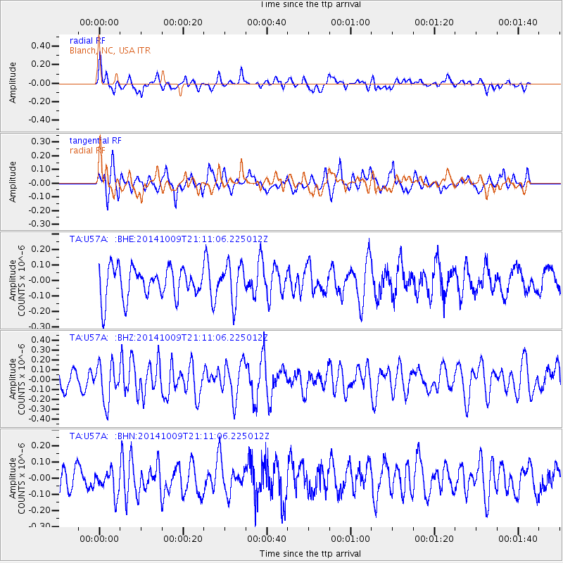
U57A Blanch, NC, USA - Earthquake Result Viewer
*The percent match for this event was below the threshold and hence no stack was calculated.
| Earthquake location: |
Easter Island Region |
| Earthquake latitude/longitude: |
-32.0/-111.1 |
| Earthquake time(UTC): |
2014/10/09 (282) 21:00:00 GMT |
| Earthquake Depth: |
10 km |
| Earthquake Magnitude: |
5.7 MWW, 5.6 MWC |
| Earthquake Catalog/Contributor: |
NEIC PDE/NEIC COMCAT |
|
| Network: |
TA USArray Transportable Network (new EarthScope stations) |
| Station: |
U57A Blanch, NC, USA |
| Lat/Lon: |
36.43 N/79.34 W |
| Elevation: |
178 m |
|
| Distance: |
74.3 deg |
| Az: |
26.198 deg |
| Baz: |
207.72 deg |
| Ray Param: |
$rayparam |
*The percent match for this event was below the threshold and hence was not used in the summary stack. |
|
| Radial Match: |
56.332275 % |
| Radial Bump: |
400 |
| Transverse Match: |
42.303898 % |
| Transverse Bump: |
400 |
| SOD ConfigId: |
803114 |
| Insert Time: |
2014-10-27 00:03:24.326 +0000 |
| GWidth: |
2.5 |
| Max Bumps: |
400 |
| Tol: |
0.001 |
|
Signal To Noise
| Channel | StoN | STA | LTA |
| TA:U57A: :BHZ:20141009T21:11:06.225012Z | 1.9887383 | 1.9724546E-7 | 9.918121E-8 |
| TA:U57A: :BHN:20141009T21:11:06.225012Z | 1.258229 | 9.002377E-8 | 7.1548E-8 |
| TA:U57A: :BHE:20141009T21:11:06.225012Z | 1.2370834 | 1.2300723E-7 | 9.943325E-8 |
| Arrivals |
| Ps | |
| PpPs | |
| PsPs/PpSs | |


