You are here: Home > Network List > IU - Global Seismograph Network (GSN - IRIS/USGS) Stations List
> Station GRFO Grafenberg, Germany > Earthquake Result Viewer
GRFO Grafenberg, Germany - Earthquake Result Viewer

| Earthquake location: |
Kuril Islands |
| Earthquake latitude/longitude: |
44.3/148.4 |
| Earthquake time(UTC): |
2001/05/25 (145) 00:40:50 GMT |
| Earthquake Depth: |
33 km |
| Earthquake Magnitude: |
6.1 MB, 6.7 MS, 6.7 MW, 6.6 MW |
| Earthquake Catalog/Contributor: |
WHDF/NEIC |
|
| Network: |
IU Global Seismograph Network (GSN - IRIS/USGS) |
| Station: |
GRFO Grafenberg, Germany |
| Lat/Lon: |
49.69 N/11.22 E |
| Elevation: |
425 m |
|
| Distance: |
79.2 deg |
| Az: |
333.295 deg |
| Baz: |
29.811 deg |
| Ray Param: |
0.04905474 |
| Estimated Moho Depth: |
29.5 km |
| Estimated Crust Vp/Vs: |
1.89 |
| Assumed Crust Vp: |
6.182 km/s |
| Estimated Crust Vs: |
3.262 km/s |
| Estimated Crust Poisson's Ratio: |
0.31 |
|
| Radial Match: |
95.39427 % |
| Radial Bump: |
319 |
| Transverse Match: |
88.61252 % |
| Transverse Bump: |
400 |
| SOD ConfigId: |
4714 |
| Insert Time: |
2010-03-02 02:26:59.825 +0000 |
| GWidth: |
2.5 |
| Max Bumps: |
400 |
| Tol: |
0.001 |
|
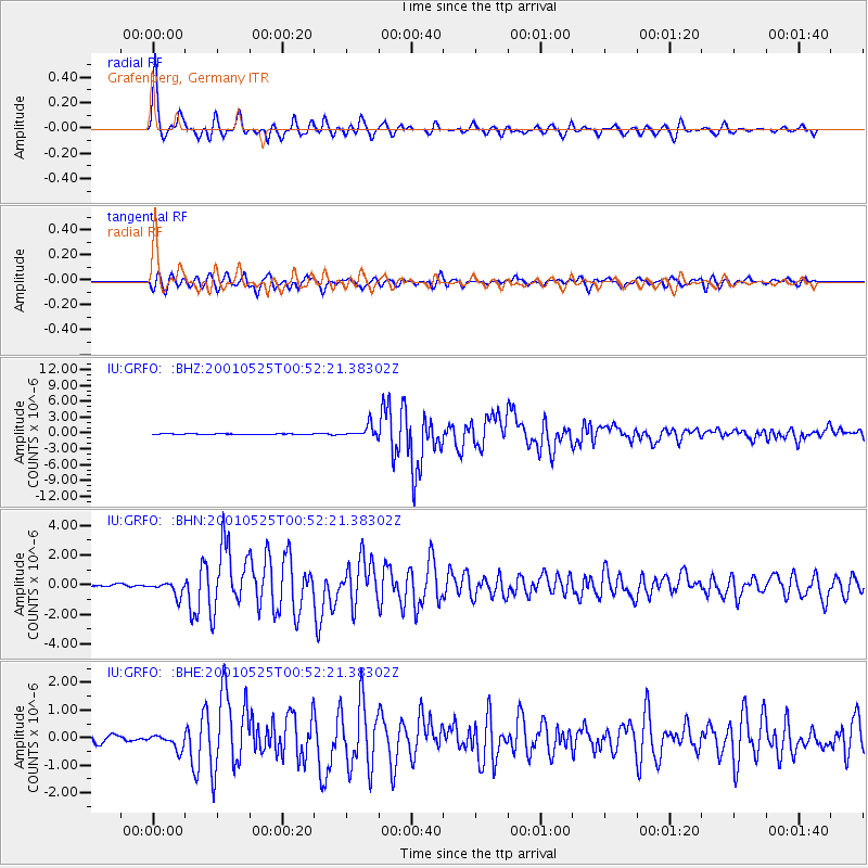
Signal To Noise
| Channel | StoN | STA | LTA |
| IU:GRFO: :BHN:20010525T00:52:21.38302Z | 4.2713532 | 4.7873203E-7 | 1.12079704E-7 |
| IU:GRFO: :BHE:20010525T00:52:21.38302Z | 2.3303719 | 2.7393682E-7 | 1.1755069E-7 |
| IU:GRFO: :BHZ:20010525T00:52:21.38302Z | 16.763142 | 1.1504567E-6 | 6.8630136E-8 |
| Arrivals |
| Ps | 4.4 SECOND |
| PpPs | 13 SECOND |
| PsPs/PpSs | 18 SECOND |


