You are here: Home > Network List > CI - Caltech Regional Seismic Network Stations List
> Station DAN Danby, California, USA > Earthquake Result Viewer
DAN Danby, California, USA - Earthquake Result Viewer
| Earthquake location: |
Vanuatu Islands |
| Earthquake latitude/longitude: |
-14.2/167.4 |
| Earthquake time(UTC): |
2015/05/05 (125) 02:44:23 GMT |
| Earthquake Depth: |
200 km |
| Earthquake Magnitude: |
4.8 mb |
| Earthquake Catalog/Contributor: |
ISC/ISC |
|
| Network: |
CI Caltech Regional Seismic Network |
| Station: |
DAN Danby, California, USA |
| Lat/Lon: |
34.64 N/115.38 W |
| Elevation: |
398 m |
|
| Distance: |
87.8 deg |
| Az: |
53.575 deg |
| Baz: |
251.145 deg |
| Ray Param: |
0.042627554 |
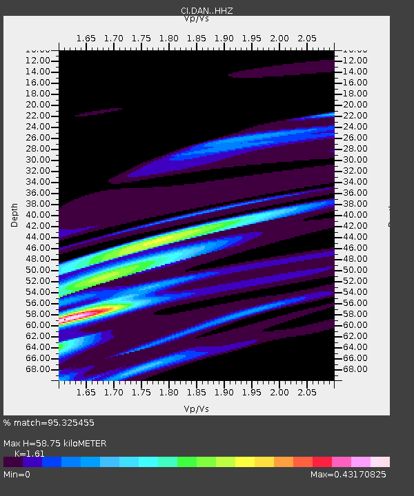
| Estimated Moho Depth: |
58.75 km |
| Estimated Crust Vp/Vs: |
1.61 |
| Assumed Crust Vp: |
6.276 km/s |
| Estimated Crust Vs: |
3.898 km/s |
| Estimated Crust Poisson's Ratio: |
0.19 |
|
| Radial Match: |
95.325455 % |
| Radial Bump: |
352 |
| Transverse Match: |
86.73646 % |
| Transverse Bump: |
300 |
| SOD ConfigId: |
7422571 |
| Insert Time: |
2019-04-18 16:30:06.178 +0000 |
| GWidth: |
2.5 |
| Max Bumps: |
400 |
| Tol: |
0.001 |
|
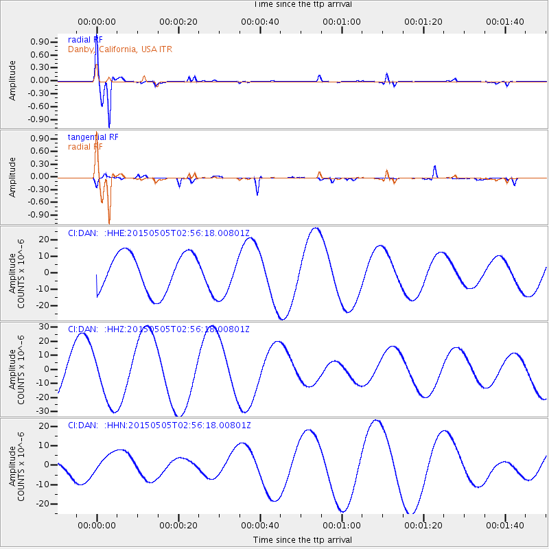
Signal To Noise
| Channel | StoN | STA | LTA |
| CI:DAN: :HHZ:20150505T02:56:18.00801Z | 1.3181306 | 1.8502838E-5 | 1.4037181E-5 |
| CI:DAN: :HHN:20150505T02:56:18.00801Z | 1.4374361 | 4.9107575E-6 | 3.416331E-6 |
| CI:DAN: :HHE:20150505T02:56:18.00801Z | 1.1051899 | 1.2687596E-5 | 1.1480014E-5 |
| Arrivals |
| Ps | 5.8 SECOND |
| PpPs | 24 SECOND |
| PsPs/PpSs | 30 SECOND |


