You are here: Home > Network List > CI - Caltech Regional Seismic Network Stations List
> Station FMP Fort MacArthur Park, Pt. Fermin San Pedro, CA, USA > Earthquake Result Viewer
FMP Fort MacArthur Park, Pt. Fermin San Pedro, CA, USA - Earthquake Result Viewer
| Earthquake location: |
Vanuatu Islands |
| Earthquake latitude/longitude: |
-14.2/167.4 |
| Earthquake time(UTC): |
2015/05/05 (125) 02:44:23 GMT |
| Earthquake Depth: |
200 km |
| Earthquake Magnitude: |
4.8 mb |
| Earthquake Catalog/Contributor: |
ISC/ISC |
|
| Network: |
CI Caltech Regional Seismic Network |
| Station: |
FMP Fort MacArthur Park, Pt. Fermin San Pedro, CA, USA |
| Lat/Lon: |
33.71 N/118.29 W |
| Elevation: |
89 m |
|
| Distance: |
85.2 deg |
| Az: |
53.631 deg |
| Baz: |
249.519 deg |
| Ray Param: |
0.04448359 |
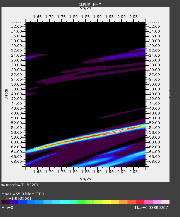
| Estimated Moho Depth: |
55.0 km |
| Estimated Crust Vp/Vs: |
1.99 |
| Assumed Crust Vp: |
6.048 km/s |
| Estimated Crust Vs: |
3.035 km/s |
| Estimated Crust Poisson's Ratio: |
0.33 |
|
| Radial Match: |
81.52281 % |
| Radial Bump: |
346 |
| Transverse Match: |
74.16953 % |
| Transverse Bump: |
400 |
| SOD ConfigId: |
7422571 |
| Insert Time: |
2019-04-18 16:30:09.730 +0000 |
| GWidth: |
2.5 |
| Max Bumps: |
400 |
| Tol: |
0.001 |
|

Signal To Noise
| Channel | StoN | STA | LTA |
| CI:FMP: :HHZ:20150505T02:56:05.50801Z | 1.1078006 | 2.1343343E-5 | 1.9266412E-5 |
| CI:FMP: :HHN:20150505T02:56:05.50801Z | 1.8991692 | 1.1292775E-5 | 5.946166E-6 |
| CI:FMP: :HHE:20150505T02:56:05.50801Z | 0.5592689 | 8.260648E-6 | 1.4770442E-5 |
| Arrivals |
| Ps | 9.2 SECOND |
| PpPs | 27 SECOND |
| PsPs/PpSs | 36 SECOND |


