You are here: Home > Network List > AK - Alaska Regional Network Stations List
> Station NICH Nichawak Mountain, AK, USA > Earthquake Result Viewer
NICH Nichawak Mountain, AK, USA - Earthquake Result Viewer
| Earthquake location: |
Off Coast Of Central America |
| Earthquake latitude/longitude: |
12.6/-88.0 |
| Earthquake time(UTC): |
2014/10/14 (287) 03:51:35 GMT |
| Earthquake Depth: |
40 km |
| Earthquake Magnitude: |
7.3 MWW, 7.4 MI |
| Earthquake Catalog/Contributor: |
NEIC PDE/NEIC COMCAT |
|
| Network: |
AK Alaska Regional Network |
| Station: |
NICH Nichawak Mountain, AK, USA |
| Lat/Lon: |
60.24 N/143.97 W |
| Elevation: |
507 m |
|
| Distance: |
62.6 deg |
| Az: |
332.254 deg |
| Baz: |
114.36 deg |
| Ray Param: |
0.060054187 |
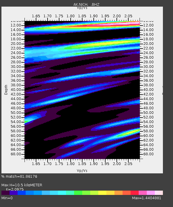
| Estimated Moho Depth: |
10.5 km |
| Estimated Crust Vp/Vs: |
2.10 |
| Assumed Crust Vp: |
6.566 km/s |
| Estimated Crust Vs: |
3.13 km/s |
| Estimated Crust Poisson's Ratio: |
0.35 |
|
| Radial Match: |
81.86176 % |
| Radial Bump: |
400 |
| Transverse Match: |
75.843315 % |
| Transverse Bump: |
400 |
| SOD ConfigId: |
803114 |
| Insert Time: |
2014-10-28 04:03:02.620 +0000 |
| GWidth: |
2.5 |
| Max Bumps: |
400 |
| Tol: |
0.001 |
|

Signal To Noise
| Channel | StoN | STA | LTA |
| AK:NICH: :BHZ:20141014T04:01:25.207996Z | 4.298239 | 3.018021E-6 | 7.0215293E-7 |
| AK:NICH: :BHN:20141014T04:01:25.207996Z | 1.6537693 | 1.2548794E-6 | 7.5879956E-7 |
| AK:NICH: :BHE:20141014T04:01:25.207996Z | 1.189295 | 1.0493836E-6 | 8.823577E-7 |
| Arrivals |
| Ps | 1.8 SECOND |
| PpPs | 4.8 SECOND |
| PsPs/PpSs | 6.6 SECOND |


