You are here: Home > Network List > AK - Alaska Regional Network Stations List
> Station RDOG Red Dog Mine, AK, USA > Earthquake Result Viewer
RDOG Red Dog Mine, AK, USA - Earthquake Result Viewer
| Earthquake location: |
Off Coast Of Central America |
| Earthquake latitude/longitude: |
12.6/-88.0 |
| Earthquake time(UTC): |
2014/10/14 (287) 03:51:35 GMT |
| Earthquake Depth: |
40 km |
| Earthquake Magnitude: |
7.3 MWW, 7.4 MI |
| Earthquake Catalog/Contributor: |
NEIC PDE/NEIC COMCAT |
|
| Network: |
AK Alaska Regional Network |
| Station: |
RDOG Red Dog Mine, AK, USA |
| Lat/Lon: |
68.05 N/162.90 W |
| Elevation: |
421 m |
|
| Distance: |
72.8 deg |
| Az: |
337.673 deg |
| Baz: |
99.339 deg |
| Ray Param: |
0.053381227 |
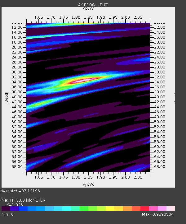
| Estimated Moho Depth: |
33.0 km |
| Estimated Crust Vp/Vs: |
1.84 |
| Assumed Crust Vp: |
5.906 km/s |
| Estimated Crust Vs: |
3.219 km/s |
| Estimated Crust Poisson's Ratio: |
0.29 |
|
| Radial Match: |
97.12196 % |
| Radial Bump: |
400 |
| Transverse Match: |
87.6877 % |
| Transverse Bump: |
400 |
| SOD ConfigId: |
803114 |
| Insert Time: |
2014-10-28 04:03:28.409 +0000 |
| GWidth: |
2.5 |
| Max Bumps: |
400 |
| Tol: |
0.001 |
|

Signal To Noise
| Channel | StoN | STA | LTA |
| AK:RDOG: :BHZ:20141014T04:02:29.187976Z | 12.090526 | 2.3242965E-6 | 1.9224115E-7 |
| AK:RDOG: :BHN:20141014T04:02:29.187976Z | 2.0092738 | 3.1180608E-7 | 1.5518347E-7 |
| AK:RDOG: :BHE:20141014T04:02:29.187976Z | 5.6992655 | 8.076451E-7 | 1.4171039E-7 |
| Arrivals |
| Ps | 4.8 SECOND |
| PpPs | 15 SECOND |
| PsPs/PpSs | 20 SECOND |


