You are here: Home > Network List > CI - Caltech Regional Seismic Network Stations List
> Station MPM Manuel Prospect Mine, California, USA > Earthquake Result Viewer
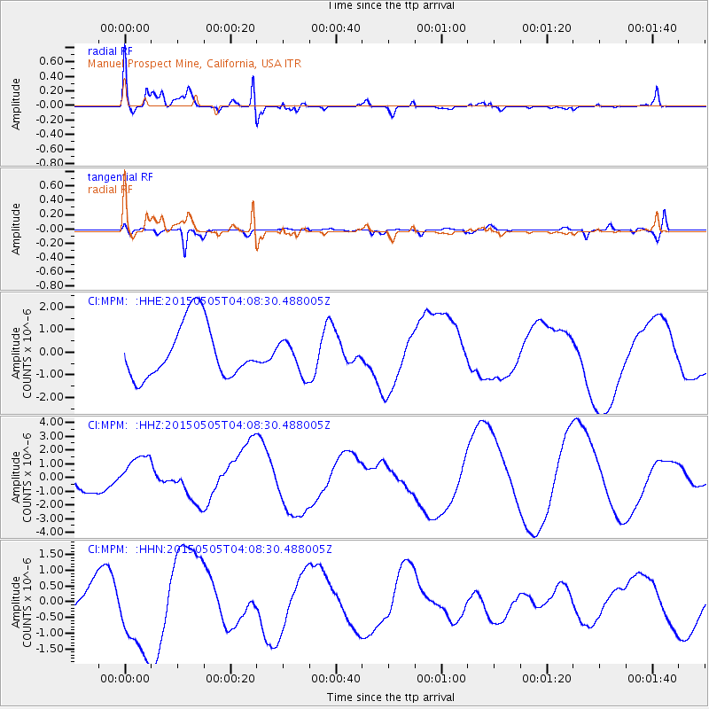
MPM Manuel Prospect Mine, California, USA - Earthquake Result Viewer
*The percent match for this event was below the threshold and hence no stack was calculated.
| Earthquake location: |
New Britain Region, P.N.G. |
| Earthquake latitude/longitude: |
-5.5/152.2 |
| Earthquake time(UTC): |
2015/05/05 (125) 03:55:51 GMT |
| Earthquake Depth: |
48 km |
| Earthquake Magnitude: |
5.4 mb |
| Earthquake Catalog/Contributor: |
ISC/ISC |
|
| Network: |
CI Caltech Regional Seismic Network |
| Station: |
MPM Manuel Prospect Mine, California, USA |
| Lat/Lon: |
36.06 N/117.49 W |
| Elevation: |
185 m |
|
| Distance: |
93.4 deg |
| Az: |
54.263 deg |
| Baz: |
265.751 deg |
| Ray Param: |
$rayparam |
*The percent match for this event was below the threshold and hence was not used in the summary stack. |
|
| Radial Match: |
72.61461 % |
| Radial Bump: |
400 |
| Transverse Match: |
51.524532 % |
| Transverse Bump: |
400 |
| SOD ConfigId: |
7422571 |
| Insert Time: |
2019-04-18 16:34:20.517 +0000 |
| GWidth: |
2.5 |
| Max Bumps: |
400 |
| Tol: |
0.001 |
|
Signal To Noise
| Channel | StoN | STA | LTA |
| CI:MPM: :HHZ:20150505T04:08:30.488005Z | 2.3010197 | 1.3998623E-6 | 6.0836607E-7 |
| CI:MPM: :HHN:20150505T04:08:30.488005Z | 3.8807774 | 1.3183529E-6 | 3.397136E-7 |
| CI:MPM: :HHE:20150505T04:08:30.488005Z | 0.62388533 | 7.534252E-7 | 1.2076341E-6 |
| Arrivals |
| Ps | |
| PpPs | |
| PsPs/PpSs | |


