You are here: Home > Network List > IU - Global Seismograph Network (GSN - IRIS/USGS) Stations List
> Station GRFO Grafenberg, Germany > Earthquake Result Viewer
GRFO Grafenberg, Germany - Earthquake Result Viewer
*The percent match for this event was below the threshold and hence no stack was calculated.
| Earthquake location: |
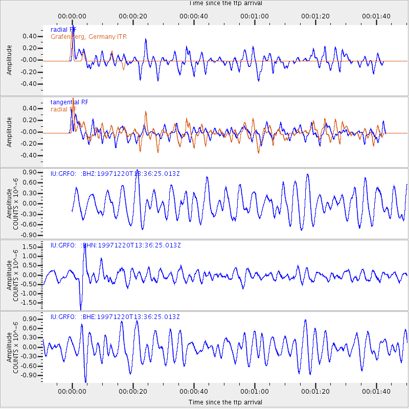
Sea Of Okhotsk |
| Earthquake latitude/longitude: |
53.4/152.8 |
| Earthquake time(UTC): |
1997/12/20 (354) 13:26:31 GMT |
| Earthquake Depth: |
614 km |
| Earthquake Magnitude: |
5.9 UNKNOWN, 5.1 MB, 5.9 MW |
| Earthquake Catalog/Contributor: |
WHDF/NEIC |
|
| Network: |
IU Global Seismograph Network (GSN - IRIS/USGS) |
| Station: |
GRFO Grafenberg, Germany |
| Lat/Lon: |
49.69 N/11.22 E |
| Elevation: |
425 m |
|
| Distance: |
72.2 deg |
| Az: |
334.906 deg |
| Baz: |
23.006 deg |
| Ray Param: |
$rayparam |
*The percent match for this event was below the threshold and hence was not used in the summary stack. |
|
| Radial Match: |
55.449398 % |
| Radial Bump: |
390 |
| Transverse Match: |
56.39658 % |
| Transverse Bump: |
400 |
| SOD ConfigId: |
4480 |
| Insert Time: |
2010-03-02 02:28:48.726 +0000 |
| GWidth: |
2.5 |
| Max Bumps: |
400 |
| Tol: |
0.001 |
|
Signal To Noise
| Channel | StoN | STA | LTA |
| IU:GRFO: :BHN:19971220T13:36:25.013Z | 2.946096 | 8.206915E-7 | 2.785692E-7 |
| IU:GRFO: :BHE:19971220T13:36:25.013Z | 1.2885075 | 4.6667788E-7 | 3.6218486E-7 |
| IU:GRFO: :BHZ:19971220T13:36:25.013Z | 0.88864595 | 3.2042135E-7 | 3.6057256E-7 |
| Arrivals |
| Ps | |
| PpPs | |
| PsPs/PpSs | |


