You are here: Home > Network List > G - GEOSCOPE Stations List
> Station PPTF Pamatai - Papeete - Tahiti island - French Polynesia, France > Earthquake Result Viewer
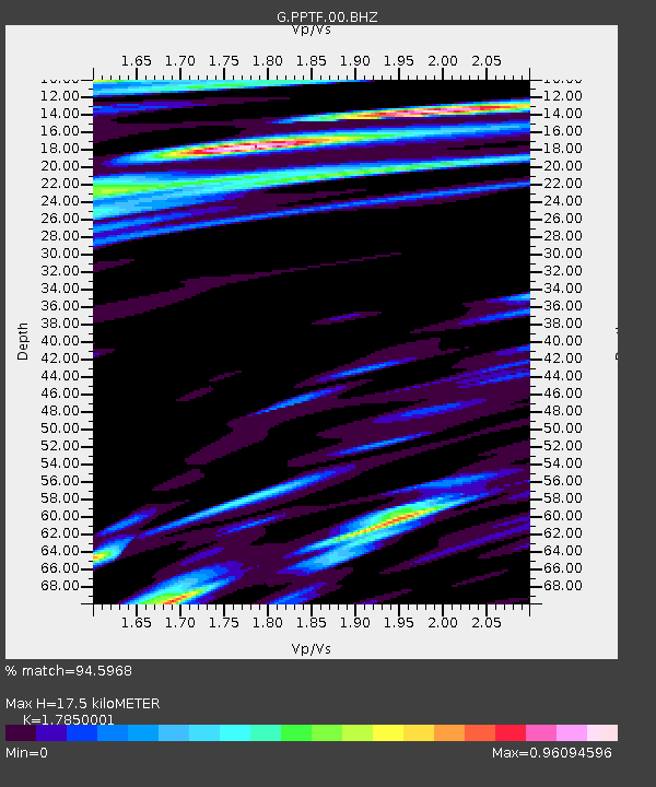
PPTF Pamatai - Papeete - Tahiti island - French Polynesia, France - Earthquake Result Viewer
| Earthquake location: |
Off Coast Of Central America |
| Earthquake latitude/longitude: |
12.6/-88.0 |
| Earthquake time(UTC): |
2014/10/14 (287) 03:51:35 GMT |
| Earthquake Depth: |
40 km |
| Earthquake Magnitude: |
7.3 MWW, 7.4 MI |
| Earthquake Catalog/Contributor: |
NEIC PDE/NEIC COMCAT |
|
| Network: |
G GEOSCOPE |
| Station: |
PPTF Pamatai - Papeete - Tahiti island - French Polynesia, France |
| Lat/Lon: |
17.59 S/149.57 W |
| Elevation: |
705 m |
|
| Distance: |
67.7 deg |
| Az: |
244.961 deg |
| Baz: |
68.03 deg |
| Ray Param: |
0.056700252 |
| Estimated Moho Depth: |
17.5 km |
| Estimated Crust Vp/Vs: |
1.79 |
| Assumed Crust Vp: |
4.24 km/s |
| Estimated Crust Vs: |
2.375 km/s |
| Estimated Crust Poisson's Ratio: |
0.27 |
|
| Radial Match: |
94.5968 % |
| Radial Bump: |
400 |
| Transverse Match: |
83.5713 % |
| Transverse Bump: |
400 |
| SOD ConfigId: |
803114 |
| Insert Time: |
2014-10-28 04:14:26.606 +0000 |
| GWidth: |
2.5 |
| Max Bumps: |
400 |
| Tol: |
0.001 |
|

Signal To Noise
| Channel | StoN | STA | LTA |
| G:PPTF:00:BHZ:20141014T04:01:58.449023Z | 6.8043084 | 1.4741375E-5 | 2.1664766E-6 |
| G:PPTF:00:BHN:20141014T04:01:58.449023Z | 2.6307647 | 3.5167272E-6 | 1.33677E-6 |
| G:PPTF:00:BHE:20141014T04:01:58.449023Z | 4.3505692 | 5.7691295E-6 | 1.3260632E-6 |
| Arrivals |
| Ps | 3.3 SECOND |
| PpPs | 11 SECOND |
| PsPs/PpSs | 15 SECOND |


