You are here: Home > Network List > IU - Global Seismograph Network (GSN - IRIS/USGS) Stations List
> Station GRFO Grafenberg, Germany > Earthquake Result Viewer
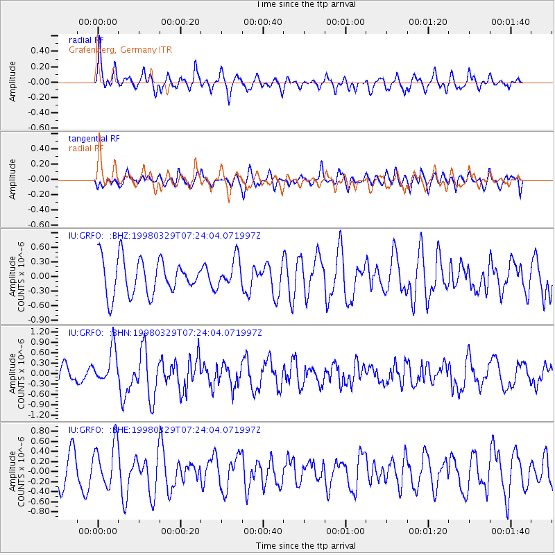
GRFO Grafenberg, Germany - Earthquake Result Viewer
*The percent match for this event was below the threshold and hence no stack was calculated.
| Earthquake location: |
North Of Ascension Island |
| Earthquake latitude/longitude: |
-0.2/-17.9 |
| Earthquake time(UTC): |
1998/03/29 (088) 07:14:58 GMT |
| Earthquake Depth: |
10 km |
| Earthquake Magnitude: |
5.5 MB, 5.6 MS, 6.1 UNKNOWN, 6.1 MW |
| Earthquake Catalog/Contributor: |
WHDF/NEIC |
|
| Network: |
IU Global Seismograph Network (GSN - IRIS/USGS) |
| Station: |
GRFO Grafenberg, Germany |
| Lat/Lon: |
49.69 N/11.22 E |
| Elevation: |
425 m |
|
| Distance: |
55.7 deg |
| Az: |
22.527 deg |
| Baz: |
216.152 deg |
| Ray Param: |
$rayparam |
*The percent match for this event was below the threshold and hence was not used in the summary stack. |
|
| Radial Match: |
58.570023 % |
| Radial Bump: |
400 |
| Transverse Match: |
53.091965 % |
| Transverse Bump: |
400 |
| SOD ConfigId: |
4480 |
| Insert Time: |
2010-03-02 02:29:52.552 +0000 |
| GWidth: |
2.5 |
| Max Bumps: |
400 |
| Tol: |
0.001 |
|
Signal To Noise
| Channel | StoN | STA | LTA |
| IU:GRFO: :BHN:19980329T07:24:04.071997Z | 3.535558 | 5.1799014E-7 | 1.4650875E-7 |
| IU:GRFO: :BHE:19980329T07:24:04.071997Z | 1.6567944 | 4.5679326E-7 | 2.7570908E-7 |
| IU:GRFO: :BHZ:19980329T07:24:04.071997Z | 0.8092792 | 2.9667032E-7 | 3.665859E-7 |
| Arrivals |
| Ps | |
| PpPs | |
| PsPs/PpSs | |


