You are here: Home > Network List > HV - Hawaiian Volcano Observatory Network Stations List
> Station RIMD Caldera Rim, Hawaii Digital > Earthquake Result Viewer
RIMD Caldera Rim, Hawaii Digital - Earthquake Result Viewer
| Earthquake location: |
Off Coast Of Central America |
| Earthquake latitude/longitude: |
12.6/-88.0 |
| Earthquake time(UTC): |
2014/10/14 (287) 03:51:35 GMT |
| Earthquake Depth: |
40 km |
| Earthquake Magnitude: |
7.3 MWW, 7.4 MI |
| Earthquake Catalog/Contributor: |
NEIC PDE/NEIC COMCAT |
|
| Network: |
HV Hawaiian Volcano Observatory Network |
| Station: |
RIMD Caldera Rim, Hawaii Digital |
| Lat/Lon: |
19.40 N/155.27 W |
| Elevation: |
1129 m |
|
| Distance: |
64.7 deg |
| Az: |
285.614 deg |
| Baz: |
84.955 deg |
| Ray Param: |
0.058713626 |
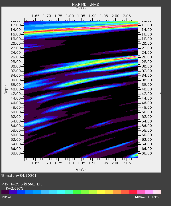
| Estimated Moho Depth: |
25.5 km |
| Estimated Crust Vp/Vs: |
2.10 |
| Assumed Crust Vp: |
5.195 km/s |
| Estimated Crust Vs: |
2.477 km/s |
| Estimated Crust Poisson's Ratio: |
0.35 |
|
| Radial Match: |
84.10301 % |
| Radial Bump: |
400 |
| Transverse Match: |
82.02653 % |
| Transverse Bump: |
400 |
| SOD ConfigId: |
803114 |
| Insert Time: |
2014-10-28 04:16:45.956 +0000 |
| GWidth: |
2.5 |
| Max Bumps: |
400 |
| Tol: |
0.001 |
|

Signal To Noise
| Channel | StoN | STA | LTA |
| HV:RIMD: :HHZ:20141014T04:01:38.793994Z | 7.4458785 | 1.6427166E-5 | 2.2062095E-6 |
| HV:RIMD: :HHN:20141014T04:01:38.793994Z | 1.2093434 | 5.6030076E-6 | 4.633099E-6 |
| HV:RIMD: :HHE:20141014T04:01:38.793994Z | 3.3267858 | 1.0758116E-5 | 3.2337869E-6 |
| Arrivals |
| Ps | 5.5 SECOND |
| PpPs | 15 SECOND |
| PsPs/PpSs | 20 SECOND |


