You are here: Home > Network List > II - Global Seismograph Network (GSN - IRIS/IDA) Stations List
> Station CMLA Cha de Macela, Sao Miguel Island, Azores > Earthquake Result Viewer
CMLA Cha de Macela, Sao Miguel Island, Azores - Earthquake Result Viewer
| Earthquake location: |
Off Coast Of Central America |
| Earthquake latitude/longitude: |
12.6/-88.0 |
| Earthquake time(UTC): |
2014/10/14 (287) 03:51:35 GMT |
| Earthquake Depth: |
40 km |
| Earthquake Magnitude: |
7.3 MWW, 7.4 MI |
| Earthquake Catalog/Contributor: |
NEIC PDE/NEIC COMCAT |
|
| Network: |
II Global Seismograph Network (GSN - IRIS/IDA) |
| Station: |
CMLA Cha de Macela, Sao Miguel Island, Azores |
| Lat/Lon: |
37.76 N/25.52 W |
| Elevation: |
429 m |
|
| Distance: |
60.7 deg |
| Az: |
53.712 deg |
| Baz: |
263.202 deg |
| Ray Param: |
0.06126173 |
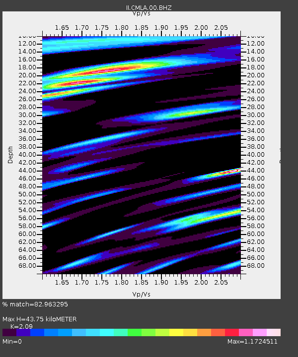
| Estimated Moho Depth: |
43.75 km |
| Estimated Crust Vp/Vs: |
2.09 |
| Assumed Crust Vp: |
4.802 km/s |
| Estimated Crust Vs: |
2.298 km/s |
| Estimated Crust Poisson's Ratio: |
0.35 |
|
| Radial Match: |
82.963295 % |
| Radial Bump: |
400 |
| Transverse Match: |
71.3144 % |
| Transverse Bump: |
400 |
| SOD ConfigId: |
803114 |
| Insert Time: |
2014-10-28 04:17:05.343 +0000 |
| GWidth: |
2.5 |
| Max Bumps: |
400 |
| Tol: |
0.001 |
|
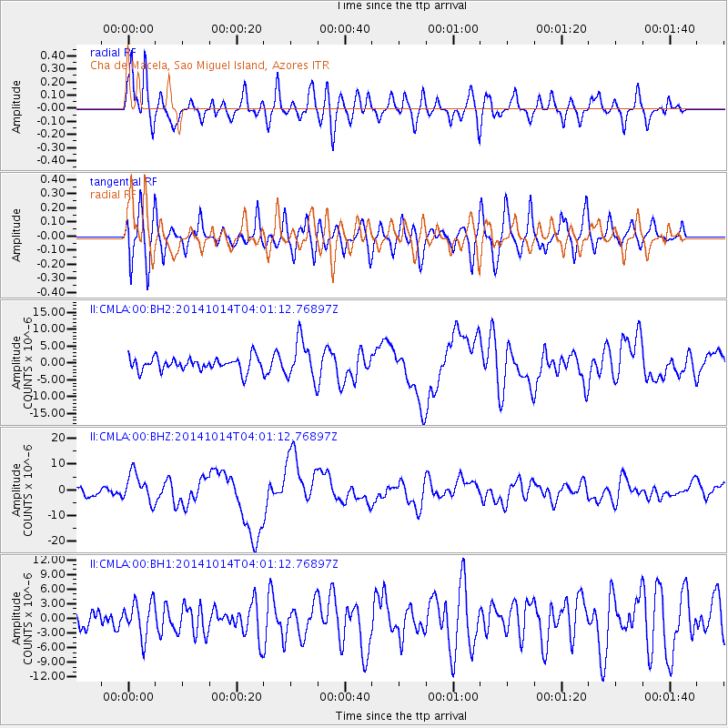
Signal To Noise
| Channel | StoN | STA | LTA |
| II:CMLA:00:BHZ:20141014T04:01:12.76897Z | 3.0210261 | 5.803411E-6 | 1.9210065E-6 |
| II:CMLA:00:BH1:20141014T04:01:12.76897Z | 1.8529756 | 3.685884E-6 | 1.9891702E-6 |
| II:CMLA:00:BH2:20141014T04:01:12.76897Z | 2.9773839 | 5.8939418E-6 | 1.9795707E-6 |
| Arrivals |
| Ps | 10 SECOND |
| PpPs | 28 SECOND |
| PsPs/PpSs | 38 SECOND |


