You are here: Home > Network List > IU - Global Seismograph Network (GSN - IRIS/USGS) Stations List
> Station XMAS Kiritimati Island, Republic of Kiribati > Earthquake Result Viewer
XMAS Kiritimati Island, Republic of Kiribati - Earthquake Result Viewer

| Earthquake location: |
Off Coast Of Central America |
| Earthquake latitude/longitude: |
12.6/-88.0 |
| Earthquake time(UTC): |
2014/10/14 (287) 03:51:35 GMT |
| Earthquake Depth: |
40 km |
| Earthquake Magnitude: |
7.3 MWW, 7.4 MI |
| Earthquake Catalog/Contributor: |
NEIC PDE/NEIC COMCAT |
|
| Network: |
IU Global Seismograph Network (GSN - IRIS/USGS) |
| Station: |
XMAS Kiritimati Island, Republic of Kiribati |
| Lat/Lon: |
2.04 N/157.45 W |
| Elevation: |
20 m |
|
| Distance: |
69.5 deg |
| Az: |
267.461 deg |
| Baz: |
77.414 deg |
| Ray Param: |
0.05556703 |
| Estimated Moho Depth: |
17.25 km |
| Estimated Crust Vp/Vs: |
2.09 |
| Assumed Crust Vp: |
4.802 km/s |
| Estimated Crust Vs: |
2.298 km/s |
| Estimated Crust Poisson's Ratio: |
0.35 |
|
| Radial Match: |
90.423355 % |
| Radial Bump: |
400 |
| Transverse Match: |
83.50223 % |
| Transverse Bump: |
400 |
| SOD ConfigId: |
803114 |
| Insert Time: |
2014-10-28 04:18:25.405 +0000 |
| GWidth: |
2.5 |
| Max Bumps: |
400 |
| Tol: |
0.001 |
|
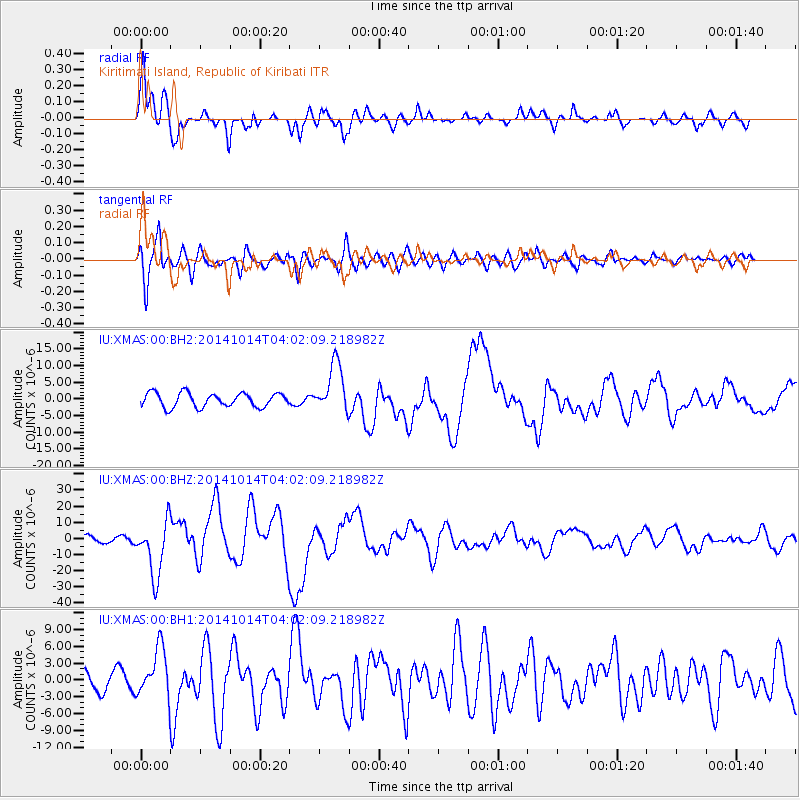
Signal To Noise
| Channel | StoN | STA | LTA |
| IU:XMAS:00:BHZ:20141014T04:02:09.218982Z | 9.719151 | 1.7186198E-5 | 1.768282E-6 |
| IU:XMAS:00:BH1:20141014T04:02:09.218982Z | 2.4814367 | 4.4009E-6 | 1.7735289E-6 |
| IU:XMAS:00:BH2:20141014T04:02:09.218982Z | 3.5330782 | 7.4516784E-6 | 2.1091178E-6 |
| Arrivals |
| Ps | 4.0 SECOND |
| PpPs | 11 SECOND |
| PsPs/PpSs | 15 SECOND |


