You are here: Home > Network List > IW - Intermountain West Stations List
> Station DLMT Dillon, Montana, USA > Earthquake Result Viewer
DLMT Dillon, Montana, USA - Earthquake Result Viewer
| Earthquake location: |
Off Coast Of Central America |
| Earthquake latitude/longitude: |
12.6/-88.0 |
| Earthquake time(UTC): |
2014/10/14 (287) 03:51:35 GMT |
| Earthquake Depth: |
40 km |
| Earthquake Magnitude: |
7.3 MWW, 7.4 MI |
| Earthquake Catalog/Contributor: |
NEIC PDE/NEIC COMCAT |
|
| Network: |
IW Intermountain West |
| Station: |
DLMT Dillon, Montana, USA |
| Lat/Lon: |
45.36 N/112.60 W |
| Elevation: |
1569 m |
|
| Distance: |
38.8 deg |
| Az: |
332.119 deg |
| Baz: |
139.639 deg |
| Ray Param: |
0.07527286 |
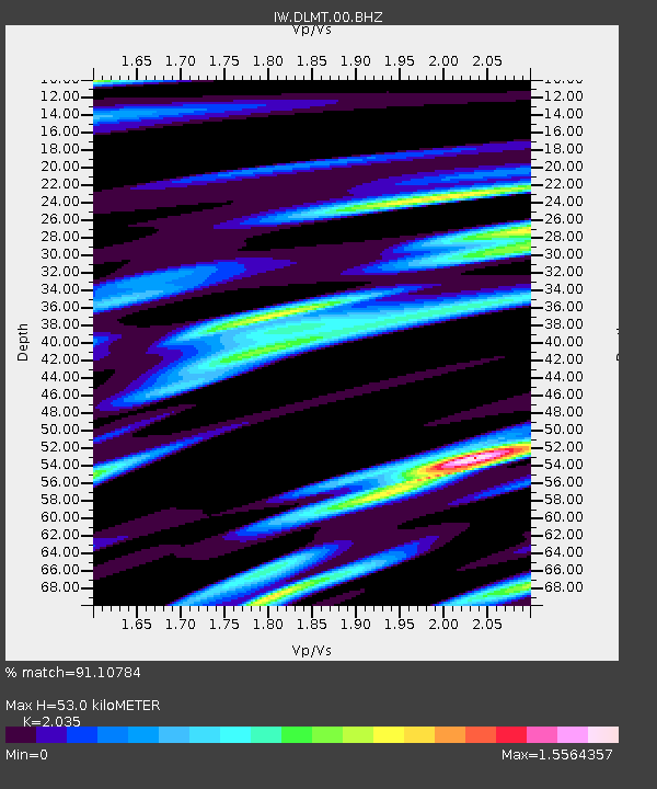
| Estimated Moho Depth: |
53.0 km |
| Estimated Crust Vp/Vs: |
2.04 |
| Assumed Crust Vp: |
6.577 km/s |
| Estimated Crust Vs: |
3.232 km/s |
| Estimated Crust Poisson's Ratio: |
0.34 |
|
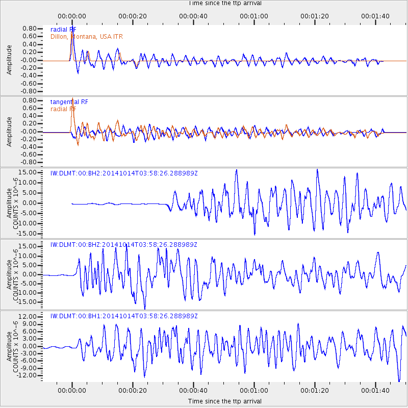
| Radial Match: |
91.10784 % |
| Radial Bump: |
400 |
| Transverse Match: |
83.95037 % |
| Transverse Bump: |
400 |
| SOD ConfigId: |
803114 |
| Insert Time: |
2014-10-28 04:18:33.377 +0000 |
| GWidth: |
2.5 |
| Max Bumps: |
400 |
| Tol: |
0.001 |
|
Signal To Noise
| Channel | StoN | STA | LTA |
| IW:DLMT:00:BHZ:20141014T03:58:26.288989Z | 42.6819 | 4.8821817E-6 | 1.143853E-7 |
| IW:DLMT:00:BH1:20141014T03:58:26.288989Z | 8.845718 | 2.257274E-6 | 2.5518267E-7 |
| IW:DLMT:00:BH2:20141014T03:58:26.288989Z | 12.636564 | 2.544605E-6 | 2.0136841E-7 |
| Arrivals |
| Ps | 8.9 SECOND |
| PpPs | 23 SECOND |
| PsPs/PpSs | 32 SECOND |


