You are here: Home > Network List > LD - Lamont-Doherty Cooperative Seismographic Network Stations List
> Station FLET Fletcher, VT > Earthquake Result Viewer
FLET Fletcher, VT - Earthquake Result Viewer
| Earthquake location: |
Off Coast Of Central America |
| Earthquake latitude/longitude: |
12.6/-88.0 |
| Earthquake time(UTC): |
2014/10/14 (287) 03:51:35 GMT |
| Earthquake Depth: |
40 km |
| Earthquake Magnitude: |
7.3 MWW, 7.4 MI |
| Earthquake Catalog/Contributor: |
NEIC PDE/NEIC COMCAT |
|
| Network: |
LD Lamont-Doherty Cooperative Seismographic Network |
| Station: |
FLET Fletcher, VT |
| Lat/Lon: |
44.72 N/72.95 W |
| Elevation: |
366 m |
|
| Distance: |
34.5 deg |
| Az: |
19.111 deg |
| Baz: |
206.641 deg |
| Ray Param: |
0.07760402 |
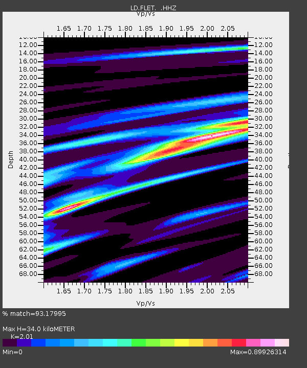
| Estimated Moho Depth: |
34.0 km |
| Estimated Crust Vp/Vs: |
2.01 |
| Assumed Crust Vp: |
6.419 km/s |
| Estimated Crust Vs: |
3.194 km/s |
| Estimated Crust Poisson's Ratio: |
0.34 |
|
| Radial Match: |
93.17995 % |
| Radial Bump: |
191 |
| Transverse Match: |
82.014915 % |
| Transverse Bump: |
400 |
| SOD ConfigId: |
803114 |
| Insert Time: |
2014-10-28 04:19:38.286 +0000 |
| GWidth: |
2.5 |
| Max Bumps: |
400 |
| Tol: |
0.001 |
|

Signal To Noise
| Channel | StoN | STA | LTA |
| LD:FLET: :HHZ:20141014T03:57:50.259998Z | 21.0298 | 7.86463E-6 | 3.739755E-7 |
| LD:FLET: :HHN:20141014T03:57:50.259998Z | 17.404259 | 4.1032213E-6 | 2.3575963E-7 |
| LD:FLET: :HHE:20141014T03:57:50.259998Z | 13.737584 | 2.8259203E-6 | 2.0570724E-7 |
| Arrivals |
| Ps | 5.7 SECOND |
| PpPs | 15 SECOND |
| PsPs/PpSs | 21 SECOND |


