You are here: Home > Network List > N4 - Central and EAstern US Network Stations List
> Station I37B Waseca, MN, USA > Earthquake Result Viewer
I37B Waseca, MN, USA - Earthquake Result Viewer
| Earthquake location: |
Off Coast Of Central America |
| Earthquake latitude/longitude: |
12.6/-88.0 |
| Earthquake time(UTC): |
2014/10/14 (287) 03:51:35 GMT |
| Earthquake Depth: |
40 km |
| Earthquake Magnitude: |
7.3 MWW, 7.4 MI |
| Earthquake Catalog/Contributor: |
NEIC PDE/NEIC COMCAT |
|
| Network: |
N4 Central and EAstern US Network |
| Station: |
I37B Waseca, MN, USA |
| Lat/Lon: |
44.01 N/93.40 W |
| Elevation: |
354 m |
|
| Distance: |
31.7 deg |
| Az: |
352.632 deg |
| Baz: |
170.007 deg |
| Ray Param: |
0.07891016 |
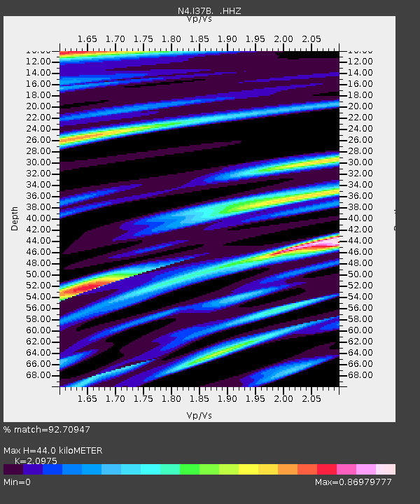
| Estimated Moho Depth: |
44.0 km |
| Estimated Crust Vp/Vs: |
2.10 |
| Assumed Crust Vp: |
6.571 km/s |
| Estimated Crust Vs: |
3.133 km/s |
| Estimated Crust Poisson's Ratio: |
0.35 |
|
| Radial Match: |
92.70947 % |
| Radial Bump: |
340 |
| Transverse Match: |
79.601265 % |
| Transverse Bump: |
400 |
| SOD ConfigId: |
803114 |
| Insert Time: |
2014-10-28 04:21:06.550 +0000 |
| GWidth: |
2.5 |
| Max Bumps: |
400 |
| Tol: |
0.001 |
|

Signal To Noise
| Channel | StoN | STA | LTA |
| N4:I37B: :HHZ:20141014T03:57:25.240009Z | 66.53286 | 1.623869E-5 | 2.4407024E-7 |
| N4:I37B: :HHN:20141014T03:57:25.240009Z | 23.25269 | 6.960923E-6 | 2.9935993E-7 |
| N4:I37B: :HHE:20141014T03:57:25.240009Z | 5.1844 | 1.4341613E-6 | 2.7663012E-7 |
| Arrivals |
| Ps | 7.9 SECOND |
| PpPs | 19 SECOND |
| PsPs/PpSs | 27 SECOND |


