You are here: Home > Network List > NI - North-East Italy Broadband Network Stations List
> Station FUSE Fusea > Earthquake Result Viewer
FUSE Fusea - Earthquake Result Viewer
| Earthquake location: |
Off Coast Of Central America |
| Earthquake latitude/longitude: |
12.6/-88.0 |
| Earthquake time(UTC): |
2014/10/14 (287) 03:51:35 GMT |
| Earthquake Depth: |
40 km |
| Earthquake Magnitude: |
7.3 MWW, 7.4 MI |
| Earthquake Catalog/Contributor: |
NEIC PDE/NEIC COMCAT |
|
| Network: |
NI North-East Italy Broadband Network |
| Station: |
FUSE Fusea |
| Lat/Lon: |
46.41 N/13.00 E |
| Elevation: |
574 m |
|
| Distance: |
88.5 deg |
| Az: |
42.788 deg |
| Baz: |
286.551 deg |
| Ray Param: |
0.04250741 |
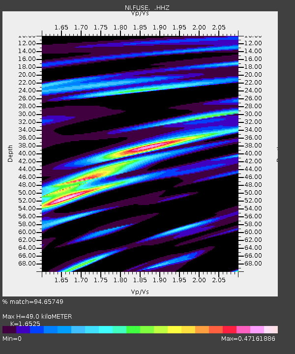
| Estimated Moho Depth: |
49.0 km |
| Estimated Crust Vp/Vs: |
1.65 |
| Assumed Crust Vp: |
6.35 km/s |
| Estimated Crust Vs: |
3.843 km/s |
| Estimated Crust Poisson's Ratio: |
0.21 |
|
| Radial Match: |
94.65749 % |
| Radial Bump: |
400 |
| Transverse Match: |
89.39421 % |
| Transverse Bump: |
400 |
| SOD ConfigId: |
803114 |
| Insert Time: |
2014-10-28 04:22:24.267 +0000 |
| GWidth: |
2.5 |
| Max Bumps: |
400 |
| Tol: |
0.001 |
|

Signal To Noise
| Channel | StoN | STA | LTA |
| NI:FUSE: :HHZ:20141014T04:03:52.827991Z | 25.857832 | 1.8979896E-6 | 7.3400955E-8 |
| NI:FUSE: :HHN:20141014T04:03:52.827991Z | 2.424778 | 1.8432958E-7 | 7.601915E-8 |
| NI:FUSE: :HHE:20141014T04:03:52.827991Z | 7.2463183 | 5.140364E-7 | 7.09376E-8 |
| Arrivals |
| Ps | 5.2 SECOND |
| PpPs | 20 SECOND |
| PsPs/PpSs | 25 SECOND |


