You are here: Home > Network List > TA - USArray Transportable Network (new EarthScope stations) Stations List
> Station B05D Stanwood, WA, USA > Earthquake Result Viewer
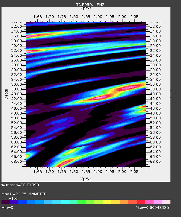
B05D Stanwood, WA, USA - Earthquake Result Viewer
| Earthquake location: |
Off Coast Of Central America |
| Earthquake latitude/longitude: |
12.6/-88.0 |
| Earthquake time(UTC): |
2014/10/14 (287) 03:51:35 GMT |
| Earthquake Depth: |
40 km |
| Earthquake Magnitude: |
7.3 MWW, 7.4 MI |
| Earthquake Catalog/Contributor: |
NEIC PDE/NEIC COMCAT |
|
| Network: |
TA USArray Transportable Network (new EarthScope stations) |
| Station: |
B05D Stanwood, WA, USA |
| Lat/Lon: |
48.26 N/122.10 W |
| Elevation: |
153 m |
|
| Distance: |
45.5 deg |
| Az: |
328.335 deg |
| Baz: |
129.913 deg |
| Ray Param: |
0.07117244 |
| Estimated Moho Depth: |
22.25 km |
| Estimated Crust Vp/Vs: |
1.60 |
| Assumed Crust Vp: |
6.566 km/s |
| Estimated Crust Vs: |
4.104 km/s |
| Estimated Crust Poisson's Ratio: |
0.18 |
|
| Radial Match: |
90.81098 % |
| Radial Bump: |
400 |
| Transverse Match: |
71.271126 % |
| Transverse Bump: |
400 |
| SOD ConfigId: |
803114 |
| Insert Time: |
2014-10-28 04:26:01.161 +0000 |
| GWidth: |
2.5 |
| Max Bumps: |
400 |
| Tol: |
0.001 |
|

Signal To Noise
| Channel | StoN | STA | LTA |
| TA:B05D: :BHZ:20141014T03:59:20.550006Z | 5.8829207 | 2.323846E-6 | 3.9501566E-7 |
| TA:B05D: :BHN:20141014T03:59:20.550006Z | 1.637799 | 6.982138E-7 | 4.2631225E-7 |
| TA:B05D: :BHE:20141014T03:59:20.550006Z | 4.1108837 | 9.878048E-7 | 2.4029015E-7 |
| Arrivals |
| Ps | 2.2 SECOND |
| PpPs | 8.2 SECOND |
| PsPs/PpSs | 10 SECOND |


