You are here: Home > Network List > TA - USArray Transportable Network (new EarthScope stations) Stations List
> Station D63A Stockholm, ME, USA > Earthquake Result Viewer
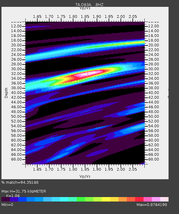
D63A Stockholm, ME, USA - Earthquake Result Viewer
| Earthquake location: |
Off Coast Of Central America |
| Earthquake latitude/longitude: |
12.6/-88.0 |
| Earthquake time(UTC): |
2014/10/14 (287) 03:51:35 GMT |
| Earthquake Depth: |
40 km |
| Earthquake Magnitude: |
7.3 MWW, 7.4 MI |
| Earthquake Catalog/Contributor: |
NEIC PDE/NEIC COMCAT |
|
| Network: |
TA USArray Transportable Network (new EarthScope stations) |
| Station: |
D63A Stockholm, ME, USA |
| Lat/Lon: |
47.04 N/68.11 W |
| Elevation: |
256 m |
|
| Distance: |
38.2 deg |
| Az: |
22.146 deg |
| Baz: |
212.554 deg |
| Ray Param: |
0.07559399 |
| Estimated Moho Depth: |
31.75 km |
| Estimated Crust Vp/Vs: |
1.86 |
| Assumed Crust Vp: |
6.419 km/s |
| Estimated Crust Vs: |
3.451 km/s |
| Estimated Crust Poisson's Ratio: |
0.30 |
|
| Radial Match: |
94.35168 % |
| Radial Bump: |
160 |
| Transverse Match: |
70.09093 % |
| Transverse Bump: |
400 |
| SOD ConfigId: |
803114 |
| Insert Time: |
2014-10-28 04:26:28.804 +0000 |
| GWidth: |
2.5 |
| Max Bumps: |
400 |
| Tol: |
0.001 |
|

Signal To Noise
| Channel | StoN | STA | LTA |
| TA:D63A: :BHZ:20141014T03:58:21.624011Z | 35.233055 | 9.752051E-6 | 2.7678698E-7 |
| TA:D63A: :BHN:20141014T03:58:21.624011Z | 21.22448 | 4.882871E-6 | 2.3005845E-7 |
| TA:D63A: :BHE:20141014T03:58:21.624011Z | 17.149063 | 3.3483107E-6 | 1.9524745E-7 |
| Arrivals |
| Ps | 4.6 SECOND |
| PpPs | 13 SECOND |
| PsPs/PpSs | 18 SECOND |


