You are here: Home > Network List > TA - USArray Transportable Network (new EarthScope stations) Stations List
> Station I63A Otisfield, ME, USA > Earthquake Result Viewer
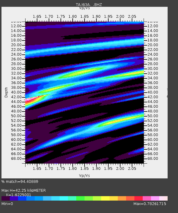
I63A Otisfield, ME, USA - Earthquake Result Viewer
| Earthquake location: |
Off Coast Of Central America |
| Earthquake latitude/longitude: |
12.6/-88.0 |
| Earthquake time(UTC): |
2014/10/14 (287) 03:51:35 GMT |
| Earthquake Depth: |
40 km |
| Earthquake Magnitude: |
7.3 MWW, 7.4 MI |
| Earthquake Catalog/Contributor: |
NEIC PDE/NEIC COMCAT |
|
| Network: |
TA USArray Transportable Network (new EarthScope stations) |
| Station: |
I63A Otisfield, ME, USA |
| Lat/Lon: |
44.05 N/70.58 W |
| Elevation: |
177 m |
|
| Distance: |
34.8 deg |
| Az: |
22.3 deg |
| Baz: |
210.917 deg |
| Ray Param: |
0.077485576 |
| Estimated Moho Depth: |
42.25 km |
| Estimated Crust Vp/Vs: |
1.62 |
| Assumed Crust Vp: |
6.419 km/s |
| Estimated Crust Vs: |
3.956 km/s |
| Estimated Crust Poisson's Ratio: |
0.19 |
|
| Radial Match: |
94.40889 % |
| Radial Bump: |
254 |
| Transverse Match: |
86.20207 % |
| Transverse Bump: |
396 |
| SOD ConfigId: |
803114 |
| Insert Time: |
2014-10-28 04:29:03.672 +0000 |
| GWidth: |
2.5 |
| Max Bumps: |
400 |
| Tol: |
0.001 |
|

Signal To Noise
| Channel | StoN | STA | LTA |
| TA:I63A: :BHZ:20141014T03:57:52.249011Z | 32.114532 | 1.099489E-5 | 3.4236493E-7 |
| TA:I63A: :BHN:20141014T03:57:52.249011Z | 19.597649 | 6.086001E-6 | 3.105475E-7 |
| TA:I63A: :BHE:20141014T03:57:52.249011Z | 13.86253 | 3.331517E-6 | 2.4032533E-7 |
| Arrivals |
| Ps | 4.5 SECOND |
| PpPs | 16 SECOND |
| PsPs/PpSs | 20 SECOND |


