You are here: Home > Network List > TA - USArray Transportable Network (new EarthScope stations) Stations List
> Station J63A Strafford, NH, USA > Earthquake Result Viewer
J63A Strafford, NH, USA - Earthquake Result Viewer
| Earthquake location: |
Off Coast Of Central America |
| Earthquake latitude/longitude: |
12.6/-88.0 |
| Earthquake time(UTC): |
2014/10/14 (287) 03:51:35 GMT |
| Earthquake Depth: |
40 km |
| Earthquake Magnitude: |
7.3 MWW, 7.4 MI |
| Earthquake Catalog/Contributor: |
NEIC PDE/NEIC COMCAT |
|
| Network: |
TA USArray Transportable Network (new EarthScope stations) |
| Station: |
J63A Strafford, NH, USA |
| Lat/Lon: |
43.28 N/71.08 W |
| Elevation: |
142 m |
|
| Distance: |
33.9 deg |
| Az: |
22.451 deg |
| Baz: |
210.699 deg |
| Ray Param: |
0.07790847 |
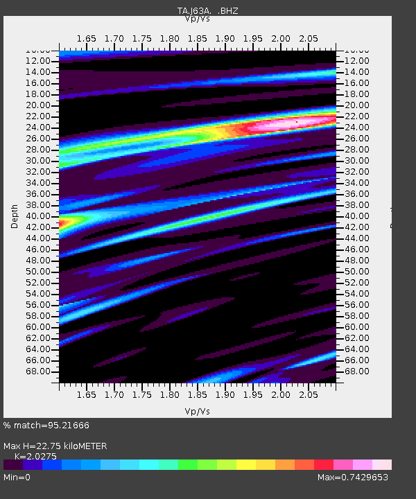
| Estimated Moho Depth: |
22.75 km |
| Estimated Crust Vp/Vs: |
2.03 |
| Assumed Crust Vp: |
6.419 km/s |
| Estimated Crust Vs: |
3.166 km/s |
| Estimated Crust Poisson's Ratio: |
0.34 |
|
| Radial Match: |
95.21666 % |
| Radial Bump: |
260 |
| Transverse Match: |
83.82292 % |
| Transverse Bump: |
400 |
| SOD ConfigId: |
803114 |
| Insert Time: |
2014-10-28 04:29:32.522 +0000 |
| GWidth: |
2.5 |
| Max Bumps: |
400 |
| Tol: |
0.001 |
|

Signal To Noise
| Channel | StoN | STA | LTA |
| TA:J63A: :BHZ:20141014T03:57:44.950Z | 39.202866 | 1.1465747E-5 | 2.9247218E-7 |
| TA:J63A: :BHN:20141014T03:57:44.950Z | 25.154871 | 6.394297E-6 | 2.5419718E-7 |
| TA:J63A: :BHE:20141014T03:57:44.950Z | 14.641804 | 3.1065792E-6 | 2.1217188E-7 |
| Arrivals |
| Ps | 3.9 SECOND |
| PpPs | 10 SECOND |
| PsPs/PpSs | 14 SECOND |


