You are here: Home > Network List > TA - USArray Transportable Network (new EarthScope stations) Stations List
> Station M02C Callahan, CA, USA > Earthquake Result Viewer
M02C Callahan, CA, USA - Earthquake Result Viewer
| Earthquake location: |
Off Coast Of Central America |
| Earthquake latitude/longitude: |
12.6/-88.0 |
| Earthquake time(UTC): |
2014/10/14 (287) 03:51:35 GMT |
| Earthquake Depth: |
40 km |
| Earthquake Magnitude: |
7.3 MWW, 7.4 MI |
| Earthquake Catalog/Contributor: |
NEIC PDE/NEIC COMCAT |
|
| Network: |
TA USArray Transportable Network (new EarthScope stations) |
| Station: |
M02C Callahan, CA, USA |
| Lat/Lon: |
41.39 N/122.85 W |
| Elevation: |
0.0 m |
|
| Distance: |
41.8 deg |
| Az: |
319.868 deg |
| Baz: |
123.241 deg |
| Ray Param: |
0.07347643 |
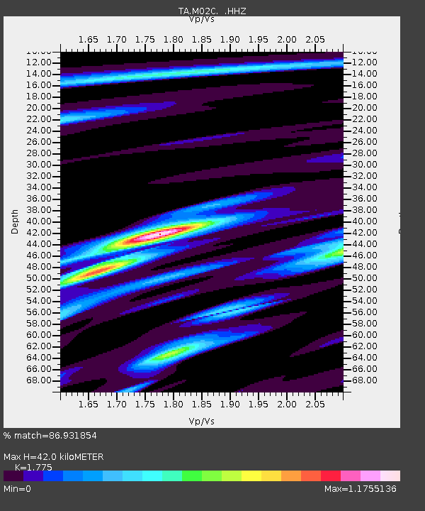
| Estimated Moho Depth: |
42.0 km |
| Estimated Crust Vp/Vs: |
1.77 |
| Assumed Crust Vp: |
6.566 km/s |
| Estimated Crust Vs: |
3.699 km/s |
| Estimated Crust Poisson's Ratio: |
0.27 |
|
| Radial Match: |
86.931854 % |
| Radial Bump: |
383 |
| Transverse Match: |
67.1526 % |
| Transverse Bump: |
351 |
| SOD ConfigId: |
803114 |
| Insert Time: |
2014-10-28 04:30:38.059 +0000 |
| GWidth: |
2.5 |
| Max Bumps: |
400 |
| Tol: |
0.001 |
|

Signal To Noise
| Channel | StoN | STA | LTA |
| TA:M02C: :HHZ:20141014T03:58:51.080005Z | 9.574632 | 2.1879787E-6 | 2.2851832E-7 |
| TA:M02C: :HHN:20141014T03:58:51.080005Z | 3.4483726 | 8.589844E-7 | 2.4909846E-7 |
| TA:M02C: :HHE:20141014T03:58:51.080005Z | 4.184156 | 1.1327209E-6 | 2.707167E-7 |
| Arrivals |
| Ps | 5.3 SECOND |
| PpPs | 17 SECOND |
| PsPs/PpSs | 22 SECOND |


