You are here: Home > Network List > TA - USArray Transportable Network (new EarthScope stations) Stations List
> Station M59A Waymart, PA, USA > Earthquake Result Viewer
M59A Waymart, PA, USA - Earthquake Result Viewer
| Earthquake location: |
Off Coast Of Central America |
| Earthquake latitude/longitude: |
12.6/-88.0 |
| Earthquake time(UTC): |
2014/10/14 (287) 03:51:35 GMT |
| Earthquake Depth: |
40 km |
| Earthquake Magnitude: |
7.3 MWW, 7.4 MI |
| Earthquake Catalog/Contributor: |
NEIC PDE/NEIC COMCAT |
|
| Network: |
TA USArray Transportable Network (new EarthScope stations) |
| Station: |
M59A Waymart, PA, USA |
| Lat/Lon: |
41.54 N/75.43 W |
| Elevation: |
471 m |
|
| Distance: |
30.9 deg |
| Az: |
18.622 deg |
| Baz: |
204.538 deg |
| Ray Param: |
0.07916945 |
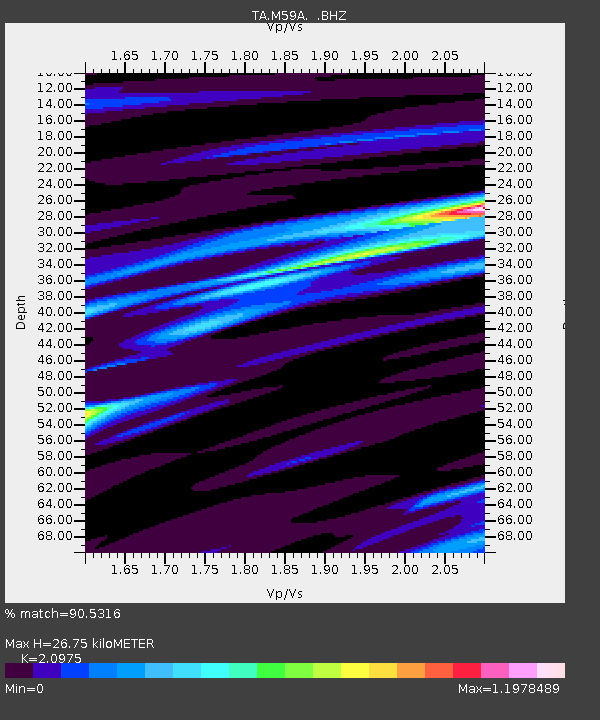
| Estimated Moho Depth: |
26.75 km |
| Estimated Crust Vp/Vs: |
2.10 |
| Assumed Crust Vp: |
6.283 km/s |
| Estimated Crust Vs: |
2.996 km/s |
| Estimated Crust Poisson's Ratio: |
0.35 |
|
| Radial Match: |
90.5316 % |
| Radial Bump: |
288 |
| Transverse Match: |
80.759705 % |
| Transverse Bump: |
400 |
| SOD ConfigId: |
803114 |
| Insert Time: |
2014-10-28 04:30:50.447 +0000 |
| GWidth: |
2.5 |
| Max Bumps: |
400 |
| Tol: |
0.001 |
|
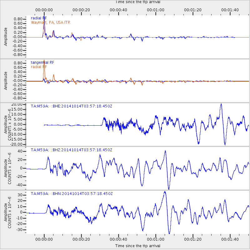
Signal To Noise
| Channel | StoN | STA | LTA |
| TA:M59A: :BHZ:20141014T03:57:18.450Z | 29.65652 | 1.1742893E-5 | 3.9596327E-7 |
| TA:M59A: :BHN:20141014T03:57:18.450Z | 21.439085 | 5.817131E-6 | 2.7133296E-7 |
| TA:M59A: :BHE:20141014T03:57:18.450Z | 13.983662 | 3.3814758E-6 | 2.418162E-7 |
| Arrivals |
| Ps | 5.0 SECOND |
| PpPs | 12 SECOND |
| PsPs/PpSs | 17 SECOND |


