You are here: Home > Network List > TA - USArray Transportable Network (new EarthScope stations) Stations List
> Station Q24A Divide, CO, USA > Earthquake Result Viewer
Q24A Divide, CO, USA - Earthquake Result Viewer
| Earthquake location: |
Off Coast Of Central America |
| Earthquake latitude/longitude: |
12.6/-88.0 |
| Earthquake time(UTC): |
2014/10/14 (287) 03:51:35 GMT |
| Earthquake Depth: |
40 km |
| Earthquake Magnitude: |
7.3 MWW, 7.4 MI |
| Earthquake Catalog/Contributor: |
NEIC PDE/NEIC COMCAT |
|
| Network: |
TA USArray Transportable Network (new EarthScope stations) |
| Station: |
Q24A Divide, CO, USA |
| Lat/Lon: |
38.96 N/105.15 W |
| Elevation: |
2775 m |
|
| Distance: |
30.3 deg |
| Az: |
333.014 deg |
| Baz: |
145.37 deg |
| Ray Param: |
0.07931194 |
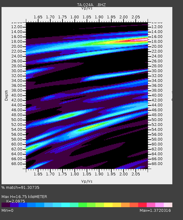
| Estimated Moho Depth: |
16.75 km |
| Estimated Crust Vp/Vs: |
2.10 |
| Assumed Crust Vp: |
6.159 km/s |
| Estimated Crust Vs: |
2.936 km/s |
| Estimated Crust Poisson's Ratio: |
0.35 |
|
| Radial Match: |
91.30735 % |
| Radial Bump: |
338 |
| Transverse Match: |
83.75753 % |
| Transverse Bump: |
400 |
| SOD ConfigId: |
803114 |
| Insert Time: |
2014-10-28 04:31:36.023 +0000 |
| GWidth: |
2.5 |
| Max Bumps: |
400 |
| Tol: |
0.001 |
|
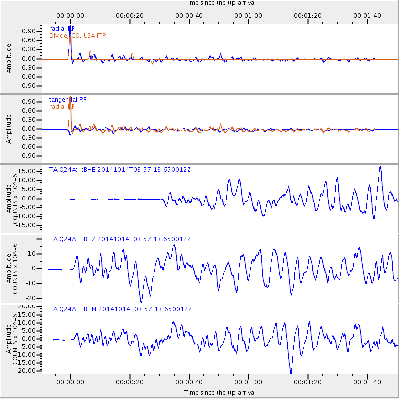
Signal To Noise
| Channel | StoN | STA | LTA |
| TA:Q24A: :BHZ:20141014T03:57:13.650012Z | 30.58146 | 4.3592995E-6 | 1.4254714E-7 |
| TA:Q24A: :BHN:20141014T03:57:13.650012Z | 16.094048 | 1.9360727E-6 | 1.2029744E-7 |
| TA:Q24A: :BHE:20141014T03:57:13.650012Z | 11.792702 | 1.897159E-6 | 1.6087569E-7 |
| Arrivals |
| Ps | 3.2 SECOND |
| PpPs | 7.9 SECOND |
| PsPs/PpSs | 11 SECOND |


