You are here: Home > Network List > US - United States National Seismic Network Stations List
> Station DGMT Dagmar, Montana, USA > Earthquake Result Viewer
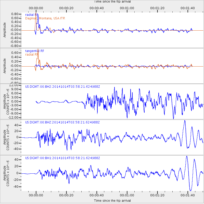
DGMT Dagmar, Montana, USA - Earthquake Result Viewer
*The percent match for this event was below the threshold and hence no stack was calculated.
| Earthquake location: |
Off Coast Of Central America |
| Earthquake latitude/longitude: |
12.6/-88.0 |
| Earthquake time(UTC): |
2014/10/14 (287) 03:51:35 GMT |
| Earthquake Depth: |
40 km |
| Earthquake Magnitude: |
7.3 MWW, 7.4 MI |
| Earthquake Catalog/Contributor: |
NEIC PDE/NEIC COMCAT |
|
| Network: |
US United States National Seismic Network |
| Station: |
DGMT Dagmar, Montana, USA |
| Lat/Lon: |
48.47 N/104.20 W |
| Elevation: |
0.0 m |
|
| Distance: |
38.2 deg |
| Az: |
342.594 deg |
| Baz: |
153.969 deg |
| Ray Param: |
$rayparam |
*The percent match for this event was below the threshold and hence was not used in the summary stack. |
|
| Radial Match: |
88.36714 % |
| Radial Bump: |
395 |
| Transverse Match: |
61.139412 % |
| Transverse Bump: |
400 |
| SOD ConfigId: |
803114 |
| Insert Time: |
2014-10-28 04:32:34.101 +0000 |
| GWidth: |
2.5 |
| Max Bumps: |
400 |
| Tol: |
0.001 |
|
Signal To Noise
| Channel | StoN | STA | LTA |
| US:DGMT:00:BHZ:20141014T03:58:21.624988Z | 40.602863 | 1.2153233E-5 | 2.993196E-7 |
| US:DGMT:00:BH1:20141014T03:58:21.624988Z | 12.222917 | 5.661504E-6 | 4.6318763E-7 |
| US:DGMT:00:BH2:20141014T03:58:21.624988Z | 4.9982233 | 2.3374093E-6 | 4.6764805E-7 |
| Arrivals |
| Ps | |
| PpPs | |
| PsPs/PpSs | |


