You are here: Home > Network List > US - United States National Seismic Network Stations List
> Station LONY Lake Ozonia, New York, USA > Earthquake Result Viewer
LONY Lake Ozonia, New York, USA - Earthquake Result Viewer
| Earthquake location: |
Off Coast Of Central America |
| Earthquake latitude/longitude: |
12.6/-88.0 |
| Earthquake time(UTC): |
2014/10/14 (287) 03:51:35 GMT |
| Earthquake Depth: |
40 km |
| Earthquake Magnitude: |
7.3 MWW, 7.4 MI |
| Earthquake Catalog/Contributor: |
NEIC PDE/NEIC COMCAT |
|
| Network: |
US United States National Seismic Network |
| Station: |
LONY Lake Ozonia, New York, USA |
| Lat/Lon: |
44.62 N/74.58 W |
| Elevation: |
440 m |
|
| Distance: |
34.0 deg |
| Az: |
17.32 deg |
| Baz: |
204.017 deg |
| Ray Param: |
0.07789627 |
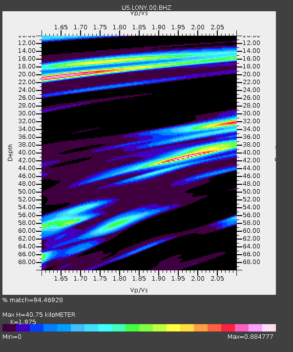
| Estimated Moho Depth: |
40.75 km |
| Estimated Crust Vp/Vs: |
1.98 |
| Assumed Crust Vp: |
6.419 km/s |
| Estimated Crust Vs: |
3.25 km/s |
| Estimated Crust Poisson's Ratio: |
0.33 |
|
| Radial Match: |
94.46928 % |
| Radial Bump: |
277 |
| Transverse Match: |
86.98955 % |
| Transverse Bump: |
342 |
| SOD ConfigId: |
803114 |
| Insert Time: |
2014-10-28 04:33:10.492 +0000 |
| GWidth: |
2.5 |
| Max Bumps: |
400 |
| Tol: |
0.001 |
|
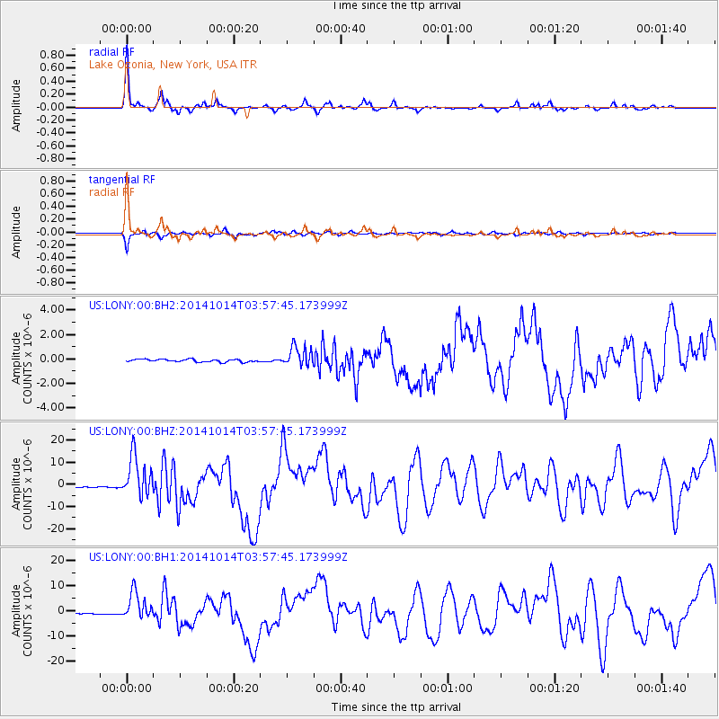
Signal To Noise
| Channel | StoN | STA | LTA |
| US:LONY:00:BHZ:20141014T03:57:45.173999Z | 37.397896 | 9.378655E-6 | 2.507803E-7 |
| US:LONY:00:BH1:20141014T03:57:45.173999Z | 25.210989 | 5.549185E-6 | 2.2010977E-7 |
| US:LONY:00:BH2:20141014T03:57:45.173999Z | 7.3772907 | 8.168356E-7 | 1.1072298E-7 |
| Arrivals |
| Ps | 6.6 SECOND |
| PpPs | 18 SECOND |
| PsPs/PpSs | 24 SECOND |


