You are here: Home > Network List > WY - Yellowstone Wyoming Seismic Network Stations List
> Station YHH Holmes Hill, YNP, WY, USA > Earthquake Result Viewer
YHH Holmes Hill, YNP, WY, USA - Earthquake Result Viewer
| Earthquake location: |
Off Coast Of Central America |
| Earthquake latitude/longitude: |
12.6/-88.0 |
| Earthquake time(UTC): |
2014/10/14 (287) 03:51:35 GMT |
| Earthquake Depth: |
40 km |
| Earthquake Magnitude: |
7.3 MWW, 7.4 MI |
| Earthquake Catalog/Contributor: |
NEIC PDE/NEIC COMCAT |
|
| Network: |
WY Yellowstone Wyoming Seismic Network |
| Station: |
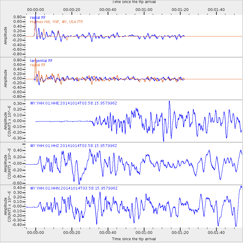
YHH Holmes Hill, YNP, WY, USA |
| Lat/Lon: |
44.79 N/110.85 W |
| Elevation: |
2717 m |
|
| Distance: |
37.6 deg |
| Az: |
333.077 deg |
| Baz: |
141.624 deg |
| Ray Param: |
0.07598256 |
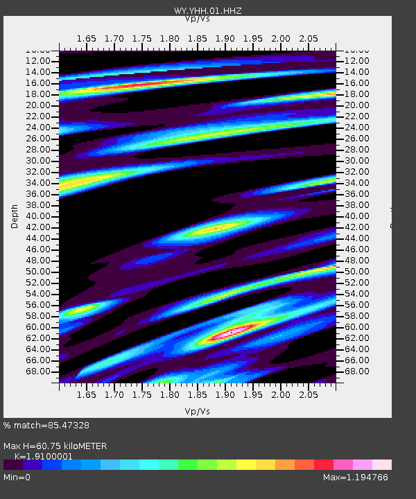
| Estimated Moho Depth: |
60.75 km |
| Estimated Crust Vp/Vs: |
1.91 |
| Assumed Crust Vp: |
6.35 km/s |
| Estimated Crust Vs: |
3.325 km/s |
| Estimated Crust Poisson's Ratio: |
0.31 |
|
| Radial Match: |
85.47328 % |
| Radial Bump: |
400 |
| Transverse Match: |
62.49016 % |
| Transverse Bump: |
400 |
| SOD ConfigId: |
803114 |
| Insert Time: |
2014-10-28 04:36:55.253 +0000 |
| GWidth: |
2.5 |
| Max Bumps: |
400 |
| Tol: |
0.001 |
|
Signal To Noise
| Channel | StoN | STA | LTA |
| WY:YHH:01:HHZ:20141014T03:58:15.957996Z | 43.71075 | 1.1343218E-7 | 2.5950637E-9 |
| WY:YHH:01:HHN:20141014T03:58:15.957996Z | 11.887243 | 4.758054E-8 | 4.0026555E-9 |
| WY:YHH:01:HHE:20141014T03:58:15.957996Z | 11.609224 | 3.404739E-8 | 2.9327876E-9 |
| Arrivals |
| Ps | 9.3 SECOND |
| PpPs | 26 SECOND |
| PsPs/PpSs | 35 SECOND |


