You are here: Home > Network List > CI - Caltech Regional Seismic Network Stations List
> Station SWS Sam W. Stewart, Westmorland, CA, USA > Earthquake Result Viewer
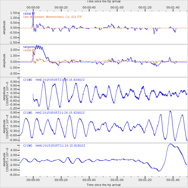
SWS Sam W. Stewart, Westmorland, CA, USA - Earthquake Result Viewer
*The percent match for this event was below the threshold and hence no stack was calculated.
| Earthquake location: |
New Britain Region, P.N.G. |
| Earthquake latitude/longitude: |
-5.5/151.8 |
| Earthquake time(UTC): |
2015/05/05 (125) 21:13:29 GMT |
| Earthquake Depth: |
45 km |
| Earthquake Magnitude: |
4.8 mb |
| Earthquake Catalog/Contributor: |
ISC/ISC |
|
| Network: |
CI Caltech Regional Seismic Network |
| Station: |
SWS Sam W. Stewart, Westmorland, CA, USA |
| Lat/Lon: |
32.94 N/115.80 W |
| Elevation: |
140 m |
|
| Distance: |
94.9 deg |
| Az: |
57.491 deg |
| Baz: |
266.676 deg |
| Ray Param: |
$rayparam |
*The percent match for this event was below the threshold and hence was not used in the summary stack. |
|
| Radial Match: |
54.45758 % |
| Radial Bump: |
400 |
| Transverse Match: |
18.099384 % |
| Transverse Bump: |
400 |
| SOD ConfigId: |
7422571 |
| Insert Time: |
2019-04-18 16:55:44.802 +0000 |
| GWidth: |
2.5 |
| Max Bumps: |
400 |
| Tol: |
0.001 |
|
Signal To Noise
| Channel | StoN | STA | LTA |
| CI:SWS: :HHZ:20150505T21:26:15.82802Z | 1.3032697 | 4.2888058E-7 | 3.2908045E-7 |
| CI:SWS: :HHN:20150505T21:26:15.82802Z | 0.9680288 | 4.800386E-7 | 4.958929E-7 |
| CI:SWS: :HHE:20150505T21:26:15.82802Z | 0.8296555 | 5.80784E-7 | 7.000302E-7 |
| Arrivals |
| Ps | |
| PpPs | |
| PsPs/PpSs | |


