You are here: Home > Network List > PY - PFO Array Stations List
> Station BPH01 Pinon Flat Observatory, CA, USA > Earthquake Result Viewer
BPH01 Pinon Flat Observatory, CA, USA - Earthquake Result Viewer
| Earthquake location: |
Off Coast Of Central America |
| Earthquake latitude/longitude: |
12.6/-88.0 |
| Earthquake time(UTC): |
2014/10/14 (287) 03:51:35 GMT |
| Earthquake Depth: |
40 km |
| Earthquake Magnitude: |
7.3 MWW, 7.4 MI |
| Earthquake Catalog/Contributor: |
NEIC PDE/NEIC COMCAT |
|
| Network: |
PY PFO Array |
| Station: |
BPH01 Pinon Flat Observatory, CA, USA |
| Lat/Lon: |
33.61 N/116.46 W |
| Elevation: |
1292 m |
|
| Distance: |
33.3 deg |
| Az: |
313.678 deg |
| Baz: |
122.208 deg |
| Ray Param: |
0.078197576 |
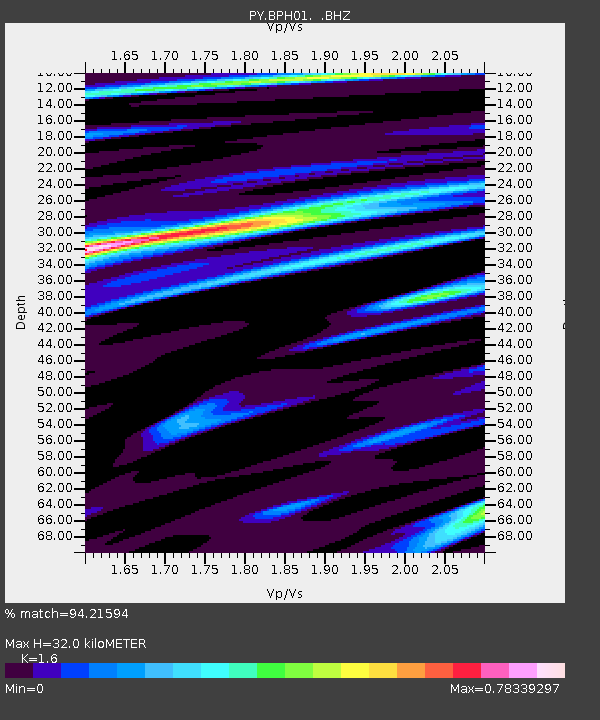
| Estimated Moho Depth: |
32.0 km |
| Estimated Crust Vp/Vs: |
1.60 |
| Assumed Crust Vp: |
6.264 km/s |
| Estimated Crust Vs: |
3.915 km/s |
| Estimated Crust Poisson's Ratio: |
0.18 |
|
| Radial Match: |
94.21594 % |
| Radial Bump: |
174 |
| Transverse Match: |
84.81074 % |
| Transverse Bump: |
400 |
| SOD ConfigId: |
803114 |
| Insert Time: |
2014-10-28 04:39:25.659 +0000 |
| GWidth: |
2.5 |
| Max Bumps: |
400 |
| Tol: |
0.001 |
|

Signal To Noise
| Channel | StoN | STA | LTA |
| PY:BPH01: :BHZ:20141014T03:57:39.499988Z | 10.714208 | 3.4974885E-6 | 3.2643464E-7 |
| PY:BPH01: :BHN:20141014T03:57:39.499988Z | 5.5491753 | 1.0382691E-6 | 1.8710332E-7 |
| PY:BPH01: :BHE:20141014T03:57:39.499988Z | 15.72718 | 2.217716E-6 | 1.4101168E-7 |
| Arrivals |
| Ps | 3.3 SECOND |
| PpPs | 12 SECOND |
| PsPs/PpSs | 16 SECOND |


