You are here: Home > Network List > IU - Global Seismograph Network (GSN - IRIS/USGS) Stations List
> Station GRFO Grafenberg, Germany > Earthquake Result Viewer
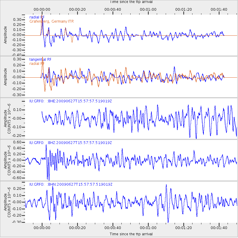
GRFO Grafenberg, Germany - Earthquake Result Viewer
*The percent match for this event was below the threshold and hence no stack was calculated.
| Earthquake location: |
Southern Mid-Atlantic Ridge |
| Earthquake latitude/longitude: |
-33.2/-15.9 |
| Earthquake time(UTC): |
2009/06/27 (178) 15:45:49 GMT |
| Earthquake Depth: |
13 km |
| Earthquake Magnitude: |
5.6 MB, 5.3 MS, 5.6 MW |
| Earthquake Catalog/Contributor: |
WHDF/NEIC |
|
| Network: |
IU Global Seismograph Network (GSN - IRIS/USGS) |
| Station: |
GRFO Grafenberg, Germany |
| Lat/Lon: |
49.69 N/11.22 E |
| Elevation: |
384 m |
|
| Distance: |
86.0 deg |
| Az: |
17.286 deg |
| Baz: |
202.557 deg |
| Ray Param: |
$rayparam |
*The percent match for this event was below the threshold and hence was not used in the summary stack. |
|
| Radial Match: |
60.901337 % |
| Radial Bump: |
400 |
| Transverse Match: |
57.91637 % |
| Transverse Bump: |
400 |
| SOD ConfigId: |
2648 |
| Insert Time: |
2010-03-02 02:34:58.355 +0000 |
| GWidth: |
2.5 |
| Max Bumps: |
400 |
| Tol: |
0.001 |
|
Signal To Noise
| Channel | StoN | STA | LTA |
| IU:GRFO: :BHZ:20090627T15:57:57.519019Z | 5.1788645 | 2.6895225E-7 | 5.1932666E-8 |
| IU:GRFO: :BHN:20090627T15:57:57.519019Z | 1.9464542 | 1.0670883E-7 | 5.4822166E-8 |
| IU:GRFO: :BHE:20090627T15:57:57.519019Z | 1.2973759 | 6.103061E-8 | 4.7041578E-8 |
| Arrivals |
| Ps | |
| PpPs | |
| PsPs/PpSs | |


