You are here: Home > Network List > IU - Global Seismograph Network (GSN - IRIS/USGS) Stations List
> Station XMAS Kiritimati Island, Republic of Kiribati > Earthquake Result Viewer
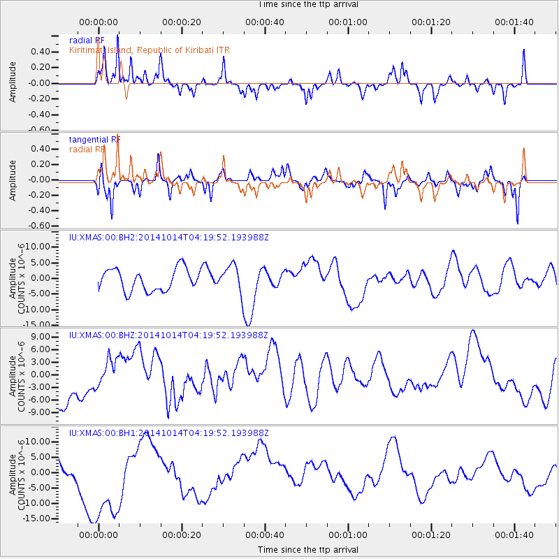
XMAS Kiritimati Island, Republic of Kiribati - Earthquake Result Viewer
*The percent match for this event was below the threshold and hence no stack was calculated.
| Earthquake location: |
South Of Kermadec Islands |
| Earthquake latitude/longitude: |
-34.9/180.0 |
| Earthquake time(UTC): |
2014/10/14 (287) 04:12:30 GMT |
| Earthquake Depth: |
32 km |
| Earthquake Magnitude: |
6.1 MB |
| Earthquake Catalog/Contributor: |
NEIC PDE/NEIC COMCAT |
|
| Network: |
IU Global Seismograph Network (GSN - IRIS/USGS) |
| Station: |
XMAS Kiritimati Island, Republic of Kiribati |
| Lat/Lon: |
2.04 N/157.45 W |
| Elevation: |
20 m |
|
| Distance: |
42.4 deg |
| Az: |
34.67 deg |
| Baz: |
207.889 deg |
| Ray Param: |
$rayparam |
*The percent match for this event was below the threshold and hence was not used in the summary stack. |
|
| Radial Match: |
73.92868 % |
| Radial Bump: |
275 |
| Transverse Match: |
67.73869 % |
| Transverse Bump: |
304 |
| SOD ConfigId: |
803114 |
| Insert Time: |
2014-10-28 04:47:49.675 +0000 |
| GWidth: |
2.5 |
| Max Bumps: |
400 |
| Tol: |
0.001 |
|
Signal To Noise
| Channel | StoN | STA | LTA |
| IU:XMAS:00:BHZ:20141014T04:19:52.193988Z | 0.57868826 | 3.0940034E-6 | 5.3465806E-6 |
| IU:XMAS:00:BH1:20141014T04:19:52.193988Z | 2.5748012 | 1.6281023E-5 | 6.323216E-6 |
| IU:XMAS:00:BH2:20141014T04:19:52.193988Z | 1.2900937 | 4.52806E-6 | 3.5098692E-6 |
| Arrivals |
| Ps | |
| PpPs | |
| PsPs/PpSs | |


