You are here: Home > Network List > UU - University of Utah Regional Network Stations List
> Station PSUT Pine Spring, UT, USA > Earthquake Result Viewer
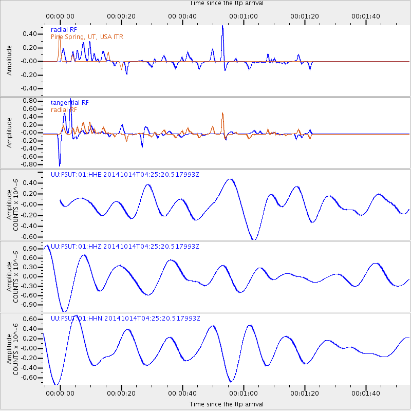
PSUT Pine Spring, UT, USA - Earthquake Result Viewer
*The percent match for this event was below the threshold and hence no stack was calculated.
| Earthquake location: |
South Of Kermadec Islands |
| Earthquake latitude/longitude: |
-34.9/180.0 |
| Earthquake time(UTC): |
2014/10/14 (287) 04:12:30 GMT |
| Earthquake Depth: |
32 km |
| Earthquake Magnitude: |
6.1 MB |
| Earthquake Catalog/Contributor: |
NEIC PDE/NEIC COMCAT |
|
| Network: |
UU University of Utah Regional Network |
| Station: |
PSUT Pine Spring, UT, USA |
| Lat/Lon: |
38.53 N/113.85 W |
| Elevation: |
1999 m |
|
| Distance: |
95.3 deg |
| Az: |
46.102 deg |
| Baz: |
229.029 deg |
| Ray Param: |
$rayparam |
*The percent match for this event was below the threshold and hence was not used in the summary stack. |
|
| Radial Match: |
72.76035 % |
| Radial Bump: |
362 |
| Transverse Match: |
91.58847 % |
| Transverse Bump: |
400 |
| SOD ConfigId: |
803114 |
| Insert Time: |
2014-10-28 04:51:18.670 +0000 |
| GWidth: |
2.5 |
| Max Bumps: |
400 |
| Tol: |
0.001 |
|
Signal To Noise
| Channel | StoN | STA | LTA |
| UU:PSUT:01:HHZ:20141014T04:25:20.517993Z | 2.4493074 | 7.950913E-7 | 3.246188E-7 |
| UU:PSUT:01:HHN:20141014T04:25:20.517993Z | 1.8388042 | 5.030638E-7 | 2.73582E-7 |
| UU:PSUT:01:HHE:20141014T04:25:20.517993Z | 1.909645 | 2.1915614E-7 | 1.1476277E-7 |
| Arrivals |
| Ps | |
| PpPs | |
| PsPs/PpSs | |


