You are here: Home > Network List > CN - Canadian National Seismograph Network Stations List
> Station INK INUVIK, NT > Earthquake Result Viewer
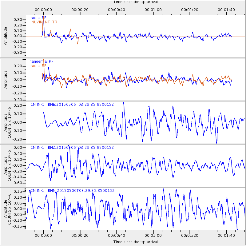
INK INUVIK, NT - Earthquake Result Viewer
*The percent match for this event was below the threshold and hence no stack was calculated.
| Earthquake location: |
New Britain Region, P.N.G. |
| Earthquake latitude/longitude: |
-5.5/152.7 |
| Earthquake time(UTC): |
2015/05/06 (126) 03:17:16 GMT |
| Earthquake Depth: |
48 km |
| Earthquake Magnitude: |
5.4 MW |
| Earthquake Catalog/Contributor: |
ISC/ISC |
|
| Network: |
CN Canadian National Seismograph Network |
| Station: |
INK INUVIK, NT |
| Lat/Lon: |
68.31 N/133.53 W |
| Elevation: |
44 m |
|
| Distance: |
89.2 deg |
| Az: |
20.922 deg |
| Baz: |
252.953 deg |
| Ray Param: |
$rayparam |
*The percent match for this event was below the threshold and hence was not used in the summary stack. |
|
| Radial Match: |
67.68142 % |
| Radial Bump: |
400 |
| Transverse Match: |
62.45183 % |
| Transverse Bump: |
400 |
| SOD ConfigId: |
7422571 |
| Insert Time: |
2019-04-18 17:00:38.032 +0000 |
| GWidth: |
2.5 |
| Max Bumps: |
400 |
| Tol: |
0.001 |
|
Signal To Noise
| Channel | StoN | STA | LTA |
| CN:INK: :BHZ:20150506T03:29:35.850015Z | 4.2875075 | 2.7515668E-7 | 6.4176376E-8 |
| CN:INK: :BHN:20150506T03:29:35.850015Z | 1.5137544 | 8.795345E-8 | 5.810286E-8 |
| CN:INK: :BHE:20150506T03:29:35.850015Z | 1.9426916 | 9.1033456E-8 | 4.685945E-8 |
| Arrivals |
| Ps | |
| PpPs | |
| PsPs/PpSs | |


