You are here: Home > Network List > IU - Global Seismograph Network (GSN - IRIS/USGS) Stations List
> Station GRFO Grafenberg, Germany > Earthquake Result Viewer
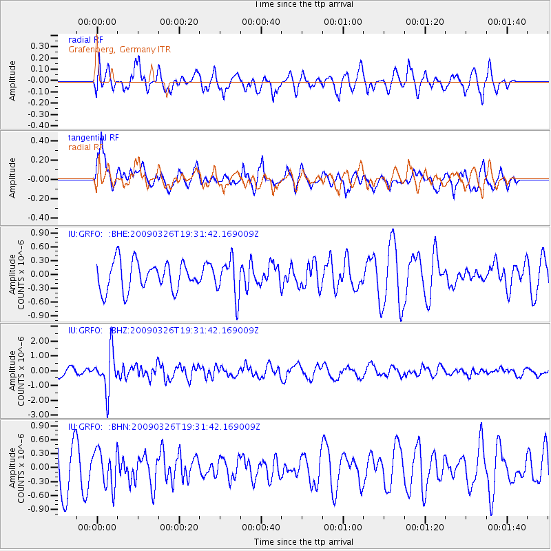
GRFO Grafenberg, Germany - Earthquake Result Viewer
*The percent match for this event was below the threshold and hence no stack was calculated.
| Earthquake location: |
Northwest Of Ryukyu Islands |
| Earthquake latitude/longitude: |
27.4/126.7 |
| Earthquake time(UTC): |
2009/03/26 (085) 19:19:59 GMT |
| Earthquake Depth: |
160 km |
| Earthquake Magnitude: |
5.6 MB, 5.9 MW, 5.9 MW |
| Earthquake Catalog/Contributor: |
WHDF/NEIC |
|
| Network: |
IU Global Seismograph Network (GSN - IRIS/USGS) |
| Station: |
GRFO Grafenberg, Germany |
| Lat/Lon: |
49.69 N/11.22 E |
| Elevation: |
384 m |
|
| Distance: |
84.3 deg |
| Az: |
323.899 deg |
| Baz: |
53.757 deg |
| Ray Param: |
$rayparam |
*The percent match for this event was below the threshold and hence was not used in the summary stack. |
|
| Radial Match: |
70.38197 % |
| Radial Bump: |
400 |
| Transverse Match: |
63.608486 % |
| Transverse Bump: |
400 |
| SOD ConfigId: |
2658 |
| Insert Time: |
2010-03-02 02:35:59.105 +0000 |
| GWidth: |
2.5 |
| Max Bumps: |
400 |
| Tol: |
0.001 |
|
Signal To Noise
| Channel | StoN | STA | LTA |
| IU:GRFO: :BHZ:20090326T19:31:42.169009Z | 6.0521684 | 1.3521083E-6 | 2.234089E-7 |
| IU:GRFO: :BHN:20090326T19:31:42.169009Z | 0.80621266 | 4.0285562E-7 | 4.99689E-7 |
| IU:GRFO: :BHE:20090326T19:31:42.169009Z | 1.3534088 | 4.165651E-7 | 3.0778955E-7 |
| Arrivals |
| Ps | |
| PpPs | |
| PsPs/PpSs | |


