You are here: Home > Network List > TA - USArray Transportable Network (new EarthScope stations) Stations List
> Station I23K Minto, Yukon-Koyukuk, AK, USA > Earthquake Result Viewer
I23K Minto, Yukon-Koyukuk, AK, USA - Earthquake Result Viewer
| Earthquake location: |
New Britain Region, P.N.G. |
| Earthquake latitude/longitude: |
-5.5/152.7 |
| Earthquake time(UTC): |
2015/05/06 (126) 03:17:16 GMT |
| Earthquake Depth: |
48 km |
| Earthquake Magnitude: |
5.4 MW |
| Earthquake Catalog/Contributor: |
ISC/ISC |
|
| Network: |
TA USArray Transportable Network (new EarthScope stations) |
| Station: |
I23K Minto, Yukon-Koyukuk, AK, USA |
| Lat/Lon: |
65.15 N/149.36 W |
| Elevation: |
149 m |
|
| Distance: |
82.2 deg |
| Az: |
21.204 deg |
| Baz: |
238.423 deg |
| Ray Param: |
0.046988793 |
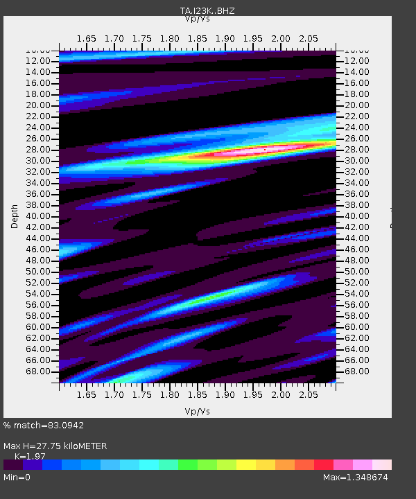
| Estimated Moho Depth: |
27.75 km |
| Estimated Crust Vp/Vs: |
1.97 |
| Assumed Crust Vp: |
6.566 km/s |
| Estimated Crust Vs: |
3.333 km/s |
| Estimated Crust Poisson's Ratio: |
0.33 |
|
| Radial Match: |
83.0942 % |
| Radial Bump: |
400 |
| Transverse Match: |
75.801926 % |
| Transverse Bump: |
400 |
| SOD ConfigId: |
7422571 |
| Insert Time: |
2019-04-18 17:02:26.299 +0000 |
| GWidth: |
2.5 |
| Max Bumps: |
400 |
| Tol: |
0.001 |
|
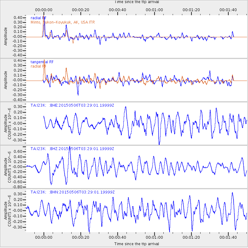
Signal To Noise
| Channel | StoN | STA | LTA |
| TA:I23K: :BHZ:20150506T03:29:01.19999Z | 5.6088977 | 3.6069162E-7 | 6.430704E-8 |
| TA:I23K: :BHN:20150506T03:29:01.19999Z | 1.9520794 | 1.1663979E-7 | 5.975156E-8 |
| TA:I23K: :BHE:20150506T03:29:01.19999Z | 0.86839813 | 7.4039484E-8 | 8.525984E-8 |
| Arrivals |
| Ps | 4.2 SECOND |
| PpPs | 12 SECOND |
| PsPs/PpSs | 16 SECOND |


