You are here: Home > Network List > IU - Global Seismograph Network (GSN - IRIS/USGS) Stations List
> Station RSSD Black Hills, South Dakota, USA > Earthquake Result Viewer
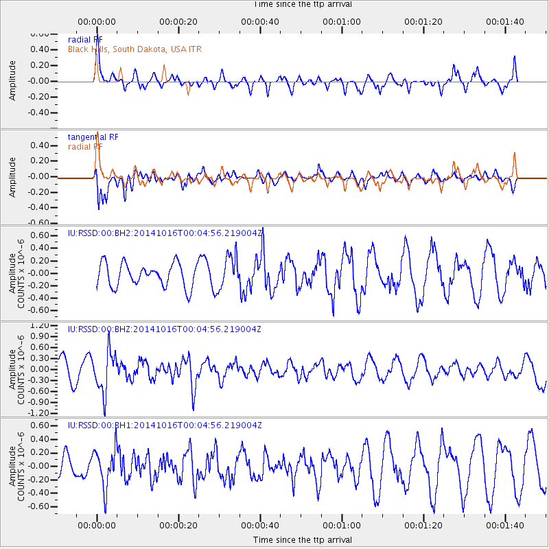
RSSD Black Hills, South Dakota, USA - Earthquake Result Viewer
*The percent match for this event was below the threshold and hence no stack was calculated.
| Earthquake location: |
Southeast Of Honshu, Japan |
| Earthquake latitude/longitude: |
31.7/140.5 |
| Earthquake time(UTC): |
2014/10/15 (288) 23:53:01 GMT |
| Earthquake Depth: |
58 km |
| Earthquake Magnitude: |
5.5 MWW, 5.5 MWC, 5.6 MWB |
| Earthquake Catalog/Contributor: |
NEIC PDE/NEIC COMCAT |
|
| Network: |
IU Global Seismograph Network (GSN - IRIS/USGS) |
| Station: |
RSSD Black Hills, South Dakota, USA |
| Lat/Lon: |
44.12 N/104.04 W |
| Elevation: |
2090 m |
|
| Distance: |
84.3 deg |
| Az: |
40.812 deg |
| Baz: |
309.363 deg |
| Ray Param: |
$rayparam |
*The percent match for this event was below the threshold and hence was not used in the summary stack. |
|
| Radial Match: |
67.439125 % |
| Radial Bump: |
389 |
| Transverse Match: |
75.94997 % |
| Transverse Bump: |
400 |
| SOD ConfigId: |
803114 |
| Insert Time: |
2014-10-30 00:20:01.261 +0000 |
| GWidth: |
2.5 |
| Max Bumps: |
400 |
| Tol: |
0.001 |
|
Signal To Noise
| Channel | StoN | STA | LTA |
| IU:RSSD:00:BHZ:20141016T00:04:56.219004Z | 2.0309312 | 5.682047E-7 | 2.7977546E-7 |
| IU:RSSD:00:BH1:20141016T00:04:56.219004Z | 1.4605353 | 2.9615268E-7 | 2.0276995E-7 |
| IU:RSSD:00:BH2:20141016T00:04:56.219004Z | 1.4739372 | 2.726416E-7 | 1.8497506E-7 |
| Arrivals |
| Ps | |
| PpPs | |
| PsPs/PpSs | |


