You are here: Home > Network List > UW - Pacific Northwest Regional Seismic Network Stations List
> Station MRBL Marblemount, WA, USA > Earthquake Result Viewer
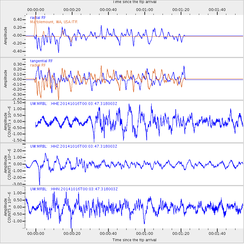
MRBL Marblemount, WA, USA - Earthquake Result Viewer
*The percent match for this event was below the threshold and hence no stack was calculated.
| Earthquake location: |
Southeast Of Honshu, Japan |
| Earthquake latitude/longitude: |
31.7/140.5 |
| Earthquake time(UTC): |
2014/10/15 (288) 23:53:01 GMT |
| Earthquake Depth: |
58 km |
| Earthquake Magnitude: |
5.5 MWW, 5.5 MWC, 5.6 MWB |
| Earthquake Catalog/Contributor: |
NEIC PDE/NEIC COMCAT |
|
| Network: |
UW Pacific Northwest Regional Seismic Network |
| Station: |
MRBL Marblemount, WA, USA |
| Lat/Lon: |
48.52 N/121.48 W |
| Elevation: |
75 m |
|
| Distance: |
71.8 deg |
| Az: |
43.873 deg |
| Baz: |
297.367 deg |
| Ray Param: |
$rayparam |
*The percent match for this event was below the threshold and hence was not used in the summary stack. |
|
| Radial Match: |
69.44986 % |
| Radial Bump: |
400 |
| Transverse Match: |
80.35361 % |
| Transverse Bump: |
400 |
| SOD ConfigId: |
803114 |
| Insert Time: |
2014-10-30 00:34:49.975 +0000 |
| GWidth: |
2.5 |
| Max Bumps: |
400 |
| Tol: |
0.001 |
|
Signal To Noise
| Channel | StoN | STA | LTA |
| UW:MRBL: :HHZ:20141016T00:03:47.318003Z | 3.2501764 | 8.5530945E-7 | 2.6315786E-7 |
| UW:MRBL: :HHN:20141016T00:03:47.318003Z | 0.7148005 | 2.536062E-7 | 3.54793E-7 |
| UW:MRBL: :HHE:20141016T00:03:47.318003Z | 2.4106376 | 5.6667244E-7 | 2.350716E-7 |
| Arrivals |
| Ps | |
| PpPs | |
| PsPs/PpSs | |


