You are here: Home > Network List > TA - USArray Transportable Network (new EarthScope stations) Stations List
> Station J01E Myrtle Point, OR, USA > Earthquake Result Viewer
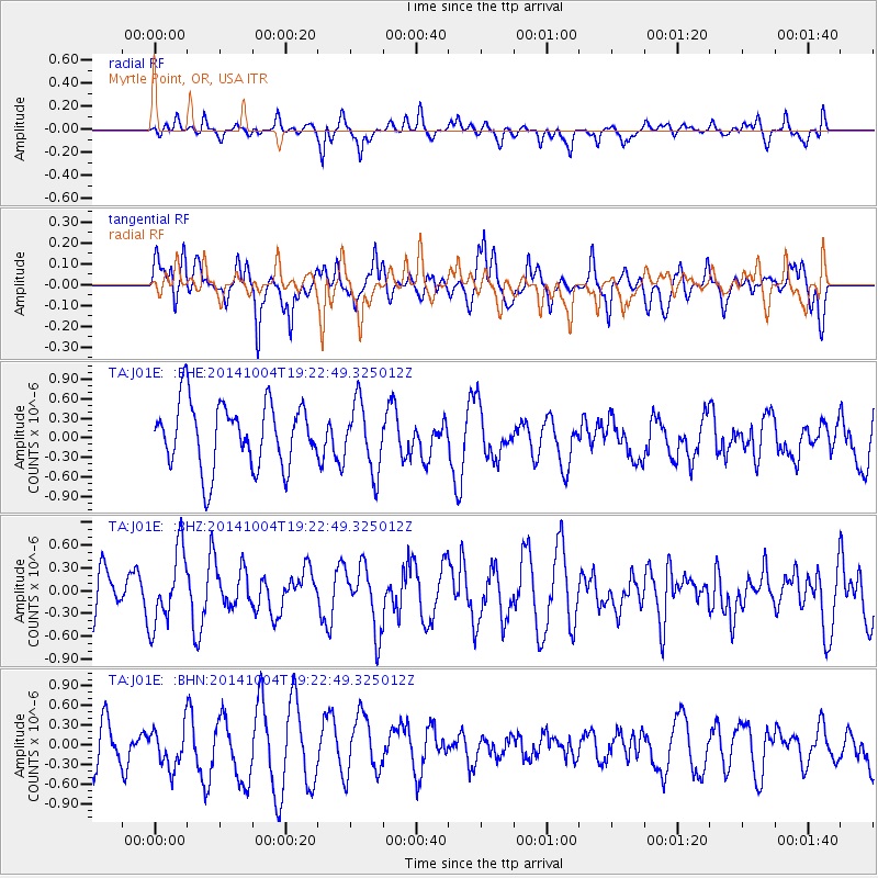
J01E Myrtle Point, OR, USA - Earthquake Result Viewer
*The percent match for this event was below the threshold and hence no stack was calculated.
| Earthquake location: |
Chiapas, Mexico |
| Earthquake latitude/longitude: |
17.4/-94.9 |
| Earthquake time(UTC): |
2014/10/04 (277) 19:16:36 GMT |
| Earthquake Depth: |
143 km |
| Earthquake Magnitude: |
5.6 MWW, 5.5 MWB, 5.7 MWC |
| Earthquake Catalog/Contributor: |
NEIC PDE/NEIC COMCAT |
|
| Network: |
TA USArray Transportable Network (new EarthScope stations) |
| Station: |
J01E Myrtle Point, OR, USA |
| Lat/Lon: |
43.16 N/123.93 W |
| Elevation: |
128 m |
|
| Distance: |
35.6 deg |
| Az: |
322.351 deg |
| Baz: |
127.149 deg |
| Ray Param: |
$rayparam |
*The percent match for this event was below the threshold and hence was not used in the summary stack. |
|
| Radial Match: |
52.493664 % |
| Radial Bump: |
400 |
| Transverse Match: |
58.816338 % |
| Transverse Bump: |
400 |
| SOD ConfigId: |
803114 |
| Insert Time: |
2014-10-31 00:44:08.305 +0000 |
| GWidth: |
2.5 |
| Max Bumps: |
400 |
| Tol: |
0.001 |
|
Signal To Noise
| Channel | StoN | STA | LTA |
| TA:J01E: :BHZ:20141004T19:22:49.325012Z | 1.357063 | 4.875702E-7 | 3.5928343E-7 |
| TA:J01E: :BHN:20141004T19:22:49.325012Z | 1.2533478 | 3.2030061E-7 | 2.5555605E-7 |
| TA:J01E: :BHE:20141004T19:22:49.325012Z | 1.0568192 | 5.2172146E-7 | 4.9367145E-7 |
| Arrivals |
| Ps | |
| PpPs | |
| PsPs/PpSs | |


