You are here: Home > Network List > IU - Global Seismograph Network (GSN - IRIS/USGS) Stations List
> Station GRFO Grafenberg, Germany > Earthquake Result Viewer
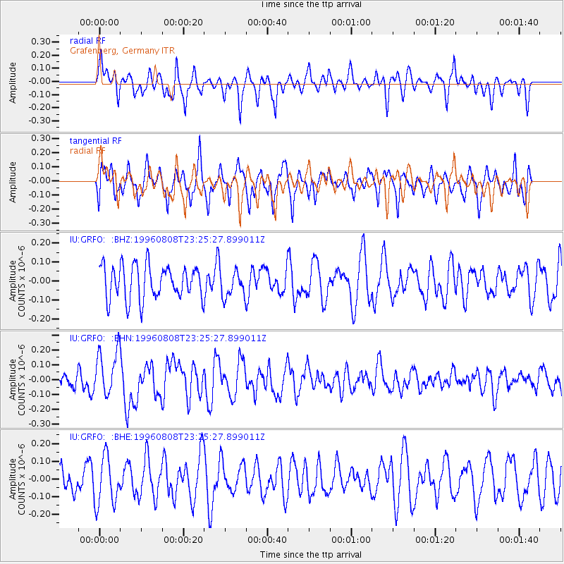
GRFO Grafenberg, Germany - Earthquake Result Viewer
*The percent match for this event was below the threshold and hence no stack was calculated.
| Earthquake location: |
Samar, Philippines |
| Earthquake latitude/longitude: |
12.0/125.7 |
| Earthquake time(UTC): |
1996/08/08 (221) 23:12:35 GMT |
| Earthquake Depth: |
33 km |
| Earthquake Magnitude: |
5.5 MS, 5.4 MB |
| Earthquake Catalog/Contributor: |
WHDF/NEIC |
|
| Network: |
IU Global Seismograph Network (GSN - IRIS/USGS) |
| Station: |
GRFO Grafenberg, Germany |
| Lat/Lon: |
49.69 N/11.22 E |
| Elevation: |
425 m |
|
| Distance: |
96.1 deg |
| Az: |
323.521 deg |
| Baz: |
63.611 deg |
| Ray Param: |
$rayparam |
*The percent match for this event was below the threshold and hence was not used in the summary stack. |
|
| Radial Match: |
59.27803 % |
| Radial Bump: |
400 |
| Transverse Match: |
65.17255 % |
| Transverse Bump: |
400 |
| SOD ConfigId: |
4480 |
| Insert Time: |
2010-03-02 02:39:27.931 +0000 |
| GWidth: |
2.5 |
| Max Bumps: |
400 |
| Tol: |
0.001 |
|
Signal To Noise
| Channel | StoN | STA | LTA |
| IU:GRFO: :BHN:19960808T23:25:27.899011Z | 2.1894648 | 1.5630775E-7 | 7.139085E-8 |
| IU:GRFO: :BHE:19960808T23:25:27.899011Z | 1.8881657 | 1.3809525E-7 | 7.313725E-8 |
| IU:GRFO: :BHZ:19960808T23:25:27.899011Z | 0.7737658 | 6.8948545E-8 | 8.910777E-8 |
| Arrivals |
| Ps | |
| PpPs | |
| PsPs/PpSs | |


