You are here: Home > Network List > TA - USArray Transportable Network (new EarthScope stations) Stations List
> Station G59A Clarenceville, QC, USA > Earthquake Result Viewer
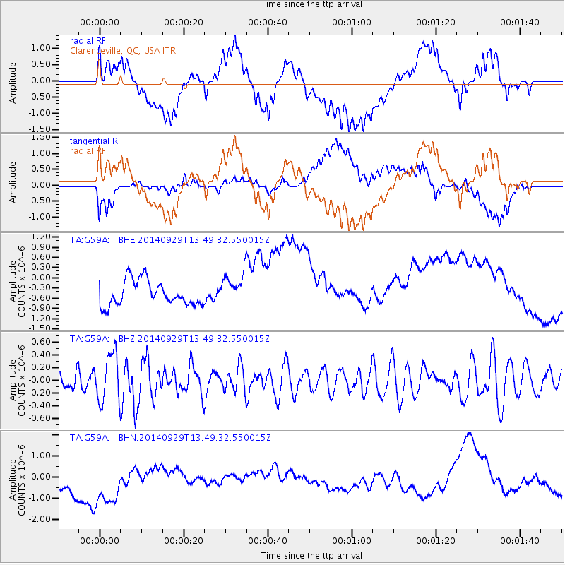
G59A Clarenceville, QC, USA - Earthquake Result Viewer
*The percent match for this event was below the threshold and hence no stack was calculated.
| Earthquake location: |
Iceland |
| Earthquake latitude/longitude: |
64.5/-17.3 |
| Earthquake time(UTC): |
2014/09/29 (272) 13:43:01 GMT |
| Earthquake Depth: |
10 km |
| Earthquake Magnitude: |
5.6 MWW, 5.5 MWC |
| Earthquake Catalog/Contributor: |
NEIC PDE/NEIC COMCAT |
|
| Network: |
TA USArray Transportable Network (new EarthScope stations) |
| Station: |
G59A Clarenceville, QC, USA |
| Lat/Lon: |
45.08 N/73.18 W |
| Elevation: |
36 m |
|
| Distance: |
36.1 deg |
| Az: |
264.836 deg |
| Baz: |
37.469 deg |
| Ray Param: |
$rayparam |
*The percent match for this event was below the threshold and hence was not used in the summary stack. |
|
| Radial Match: |
30.551163 % |
| Radial Bump: |
400 |
| Transverse Match: |
29.548193 % |
| Transverse Bump: |
400 |
| SOD ConfigId: |
803114 |
| Insert Time: |
2014-11-03 15:07:04.385 +0000 |
| GWidth: |
2.5 |
| Max Bumps: |
400 |
| Tol: |
0.001 |
|
Signal To Noise
| Channel | StoN | STA | LTA |
| TA:G59A: :BHZ:20140929T13:49:32.550015Z | 2.3601375 | 3.848698E-7 | 1.6307092E-7 |
| TA:G59A: :BHN:20140929T13:49:32.550015Z | 1.5049069 | 2.1338706E-6 | 1.417942E-6 |
| TA:G59A: :BHE:20140929T13:49:32.550015Z | 1.3379921 | 4.8264553E-7 | 3.6072376E-7 |
| Arrivals |
| Ps | |
| PpPs | |
| PsPs/PpSs | |


