You are here: Home > Network List > IU - Global Seismograph Network (GSN - IRIS/USGS) Stations List
> Station HKT Hockley, Texas > Earthquake Result Viewer
HKT Hockley, Texas - Earthquake Result Viewer
| Earthquake location: |
Peru-Bolivia Border Region |
| Earthquake latitude/longitude: |
-13.7/-68.8 |
| Earthquake time(UTC): |
1997/11/28 (332) 22:53:41 GMT |
| Earthquake Depth: |
586 km |
| Earthquake Magnitude: |
6.4 MB, 6.6 UNKNOWN, 6.6 MW |
| Earthquake Catalog/Contributor: |
WHDF/NEIC |
|
| Network: |
IU Global Seismograph Network (GSN - IRIS/USGS) |
| Station: |
HKT Hockley, Texas |
| Lat/Lon: |
29.96 N/95.84 W |
| Elevation: |
-413.0 m |
|
| Distance: |
50.7 deg |
| Az: |
329.323 deg |
| Baz: |
145.158 deg |
| Ray Param: |
0.065210715 |
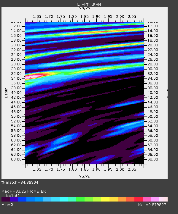
| Estimated Moho Depth: |
33.25 km |
| Estimated Crust Vp/Vs: |
1.62 |
| Assumed Crust Vp: |
5.581 km/s |
| Estimated Crust Vs: |
3.445 km/s |
| Estimated Crust Poisson's Ratio: |
0.19 |
|
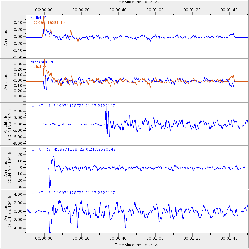
| Radial Match: |
84.36364 % |
| Radial Bump: |
400 |
| Transverse Match: |
76.16831 % |
| Transverse Bump: |
400 |
| SOD ConfigId: |
4480 |
| Insert Time: |
2010-03-02 13:49:38.513 +0000 |
| GWidth: |
2.5 |
| Max Bumps: |
400 |
| Tol: |
0.001 |
|
Signal To Noise
| Channel | StoN | STA | LTA |
| IU:HKT: :BHN:19971128T23:01:17.252014Z | 51.347057 | 1.148973E-5 | 2.237661E-7 |
| IU:HKT: :BHE:19971128T23:01:17.252014Z | 3.9217198 | 2.0107932E-6 | 5.127325E-7 |
| IU:HKT: :BHZ:19971128T23:01:17.252014Z | 12.239871 | 3.1107327E-6 | 2.5414752E-7 |
| Arrivals |
| Ps | 3.9 SECOND |
| PpPs | 15 SECOND |
| PsPs/PpSs | 19 SECOND |


