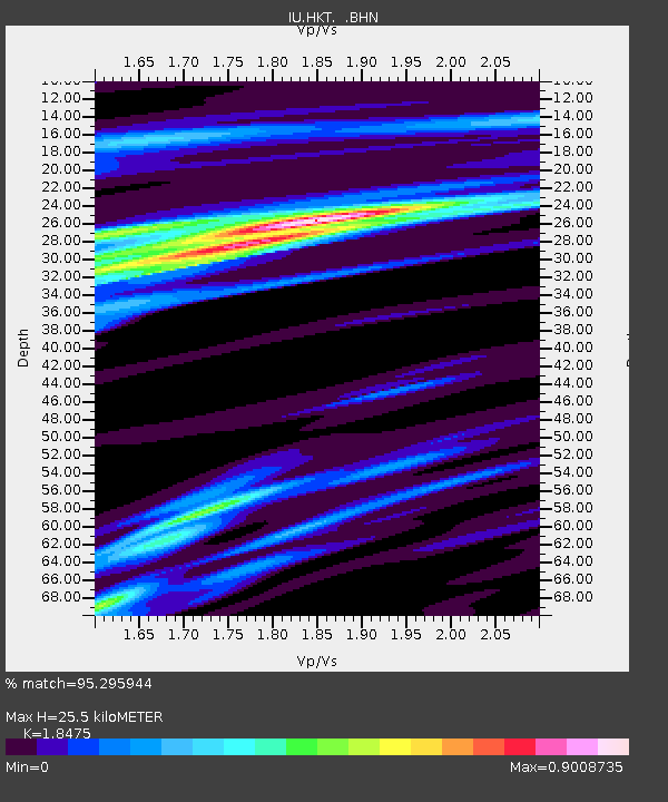
HKT Hockley, Texas - Earthquake Result Viewer
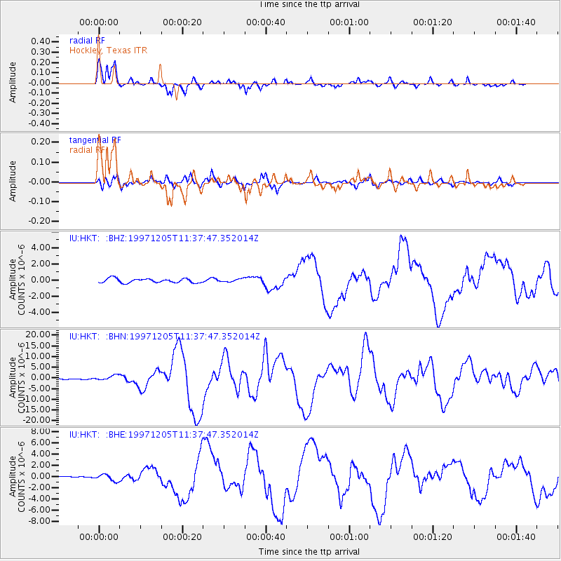
Earthquake location: Near East Coast Of Kamchatka
Earthquake latitude/longitude: 54.8/162.0
Earthquake time(UTC): 1997/12/05 (339) 11:26:54 GMT
Earthquake Depth: 33 km
Earthquake Magnitude: 6.3 MB, 7.6 MS, 7.9 UNKNOWN, 7.3 ME
Earthquake Catalog/Contributor: WHDF/NEIC
Network: IU Global Seismograph Network (GSN - IRIS/USGS)
Station: HKT Hockley, Texas
Lat/Lon: 29.96 N/95.84 W
Elevation: -413.0 m
Distance: 72.5 deg
Az: 62.795 deg
Baz: 323.643 deg
Ray Param: 0.053539306
Estimated Moho Depth: 25.5 km
Estimated Crust Vp/Vs: 1.85
Assumed Crust Vp: 5.581 km/s
Estimated Crust Vs: 3.021 km/s
Estimated Crust Poisson's Ratio: 0.29
Radial Match: 95.295944 %
Radial Bump: 319
Transverse Match: 86.96237 %
Transverse Bump: 400
SOD ConfigId: 4480
Insert Time: 2010-03-02 13:49:40.997 +0000
GWidth: 2.5
Max Bumps: 400
Tol: 0.001

Signal To Noise

ChannelStoNSTALTA
IU:HKT: :BHN:19971205T11:37:47.352014Z5.59044081.2288118E-62.198059E-7
IU:HKT: :BHE:19971205T11:37:47.352014Z2.29360185.9425764E-72.590936E-7
IU:HKT: :BHZ:19971205T11:37:47.352014Z0.70906711.8607751E-72.624258E-7
Arrivals
Ps4.0 SECOND
PpPs13 SECOND
PsPs/PpSs17 SECOND