You are here: Home > Network List > TA - USArray Transportable Network (new EarthScope stations) Stations List
> Station V61A Roper, NC, USA > Earthquake Result Viewer
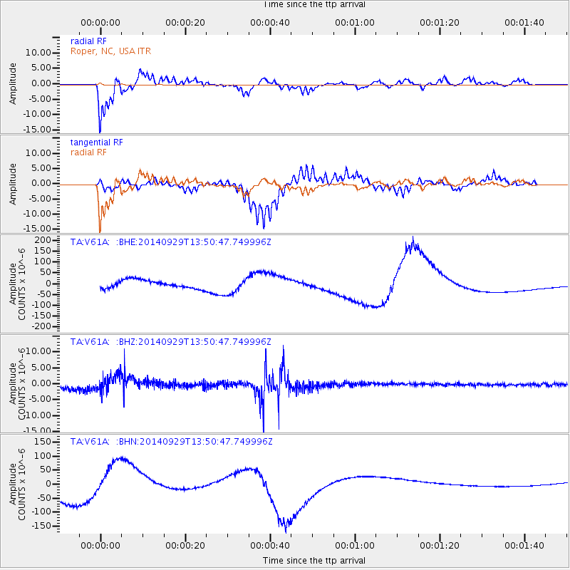
V61A Roper, NC, USA - Earthquake Result Viewer
*The percent match for this event was below the threshold and hence no stack was calculated.
| Earthquake location: |
Iceland |
| Earthquake latitude/longitude: |
64.5/-17.3 |
| Earthquake time(UTC): |
2014/09/29 (272) 13:43:01 GMT |
| Earthquake Depth: |
10 km |
| Earthquake Magnitude: |
5.6 MWW, 5.5 MWC |
| Earthquake Catalog/Contributor: |
NEIC PDE/NEIC COMCAT |
|
| Network: |
TA USArray Transportable Network (new EarthScope stations) |
| Station: |
V61A Roper, NC, USA |
| Lat/Lon: |
35.79 N/76.58 W |
| Elevation: |
4.0 m |
|
| Distance: |
45.2 deg |
| Az: |
260.046 deg |
| Baz: |
31.619 deg |
| Ray Param: |
$rayparam |
*The percent match for this event was below the threshold and hence was not used in the summary stack. |
|
| Radial Match: |
82.78206 % |
| Radial Bump: |
400 |
| Transverse Match: |
84.201965 % |
| Transverse Bump: |
288 |
| SOD ConfigId: |
803114 |
| Insert Time: |
2014-11-03 15:11:21.400 +0000 |
| GWidth: |
2.5 |
| Max Bumps: |
400 |
| Tol: |
0.001 |
|
Signal To Noise
| Channel | StoN | STA | LTA |
| TA:V61A: :BHZ:20140929T13:50:47.749996Z | 1.8418725 | 2.5901584E-6 | 1.4062638E-6 |
| TA:V61A: :BHN:20140929T13:50:47.749996Z | 1.3957276 | 6.331888E-5 | 4.5366218E-5 |
| TA:V61A: :BHE:20140929T13:50:47.749996Z | 2.0040286 | 3.755323E-5 | 1.873887E-5 |
| Arrivals |
| Ps | |
| PpPs | |
| PsPs/PpSs | |


