You are here: Home > Network List > IU - Global Seismograph Network (GSN - IRIS/USGS) Stations List
> Station HKT Hockley, Texas > Earthquake Result Viewer
HKT Hockley, Texas - Earthquake Result Viewer
| Earthquake location: |
E. Russia-N.E. China Border Reg. |
| Earthquake latitude/longitude: |
43.8/130.7 |
| Earthquake time(UTC): |
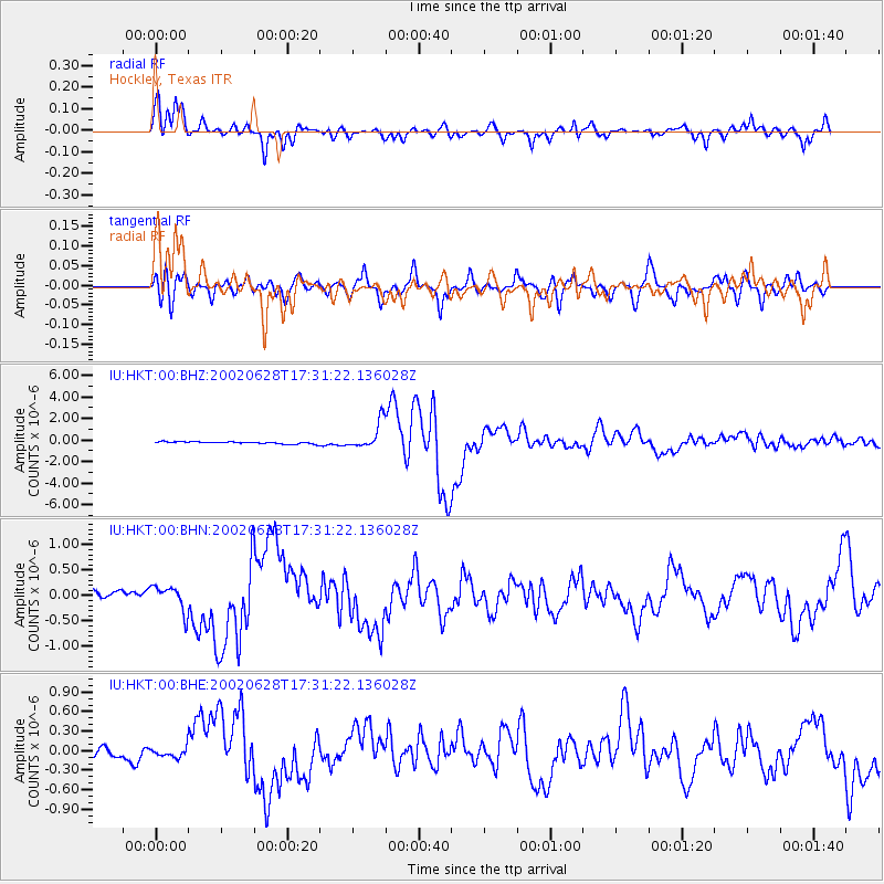
2002/06/28 (179) 17:19:30 GMT |
| Earthquake Depth: |
566 km |
| Earthquake Magnitude: |
6.7 MB, 7.3 MW, 7.3 MW |
| Earthquake Catalog/Contributor: |
WHDF/NEIC |
|
| Network: |
IU Global Seismograph Network (GSN - IRIS/USGS) |
| Station: |
HKT Hockley, Texas |
| Lat/Lon: |
29.96 N/95.84 W |
| Elevation: |
-413.0 m |
|
| Distance: |
95.2 deg |
| Az: |
39.207 deg |
| Baz: |
328.14 deg |
| Ray Param: |
0.040267203 |
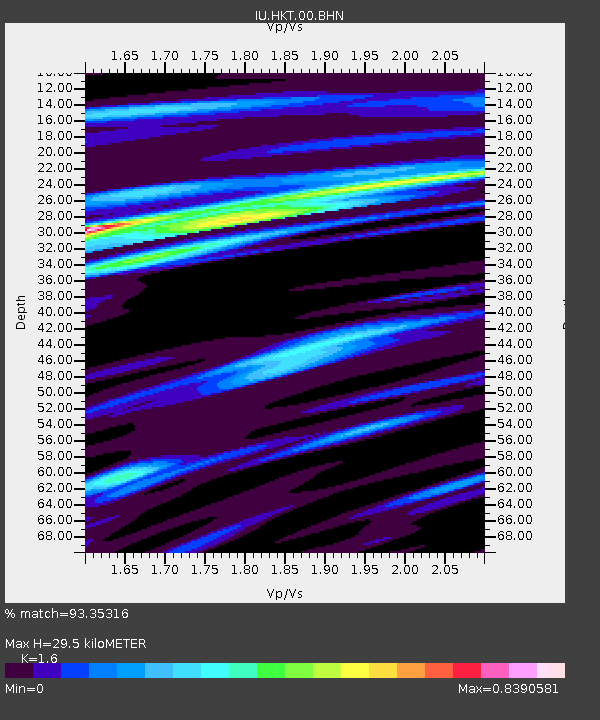
| Estimated Moho Depth: |
29.5 km |
| Estimated Crust Vp/Vs: |
1.60 |
| Assumed Crust Vp: |
5.581 km/s |
| Estimated Crust Vs: |
3.488 km/s |
| Estimated Crust Poisson's Ratio: |
0.18 |
|
| Radial Match: |
93.35316 % |
| Radial Bump: |
400 |
| Transverse Match: |
85.348595 % |
| Transverse Bump: |
400 |
| SOD ConfigId: |
20082 |
| Insert Time: |
2010-03-02 13:49:53.487 +0000 |
| GWidth: |
2.5 |
| Max Bumps: |
400 |
| Tol: |
0.001 |
|
Signal To Noise
| Channel | StoN | STA | LTA |
| IU:HKT:00:BHN:20020628T17:31:22.136028Z | 2.6778784 | 2.5061308E-7 | 9.3586436E-8 |
| IU:HKT:00:BHE:20020628T17:31:22.136028Z | 0.85032636 | 7.340557E-8 | 8.632635E-8 |
| IU:HKT:00:BHZ:20020628T17:31:22.136028Z | 12.760492 | 1.2464706E-6 | 9.7682005E-8 |
| Arrivals |
| Ps | 3.2 SECOND |
| PpPs | 14 SECOND |
| PsPs/PpSs | 17 SECOND |


