You are here: Home > Network List > IU - Global Seismograph Network (GSN - IRIS/USGS) Stations List
> Station HKT Hockley, Texas > Earthquake Result Viewer
HKT Hockley, Texas - Earthquake Result Viewer
| Earthquake location: |
Near Coast Of Central Chile |
| Earthquake latitude/longitude: |
-29.7/-71.4 |
| Earthquake time(UTC): |
2002/04/01 (091) 19:59:32 GMT |
| Earthquake Depth: |
71 km |
| Earthquake Magnitude: |
6.1 MB, 6.4 MW, 6.4 MW |
| Earthquake Catalog/Contributor: |
WHDF/NEIC |
|
| Network: |
IU Global Seismograph Network (GSN - IRIS/USGS) |
| Station: |
HKT Hockley, Texas |
| Lat/Lon: |
29.96 N/95.84 W |
| Elevation: |
-413.0 m |
|
| Distance: |
63.7 deg |
| Az: |
336.381 deg |
| Baz: |
156.308 deg |
| Ray Param: |
0.059216984 |
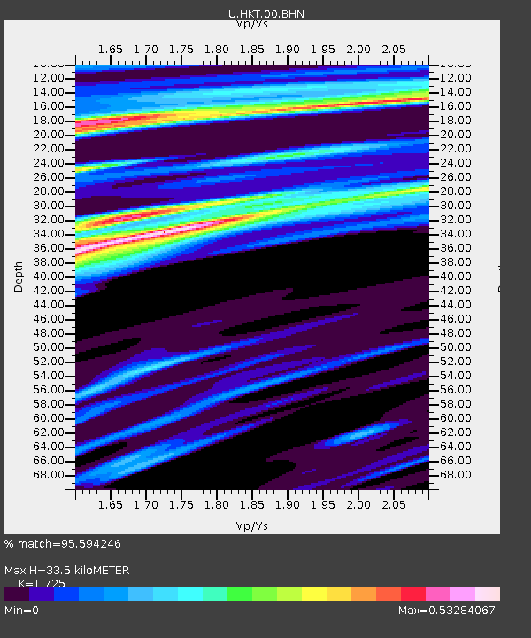
| Estimated Moho Depth: |
33.5 km |
| Estimated Crust Vp/Vs: |
1.73 |
| Assumed Crust Vp: |
5.581 km/s |
| Estimated Crust Vs: |
3.236 km/s |
| Estimated Crust Poisson's Ratio: |
0.25 |
|
| Radial Match: |
95.594246 % |
| Radial Bump: |
360 |
| Transverse Match: |
87.52766 % |
| Transverse Bump: |
400 |
| SOD ConfigId: |
20082 |
| Insert Time: |
2010-03-02 13:50:07.615 +0000 |
| GWidth: |
2.5 |
| Max Bumps: |
400 |
| Tol: |
0.001 |
|
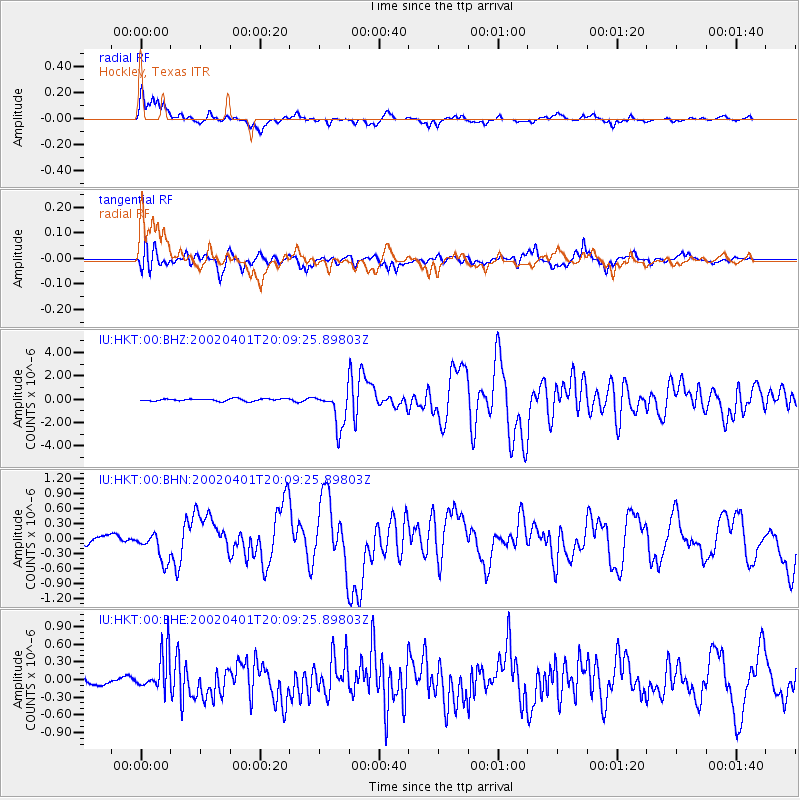
Signal To Noise
| Channel | StoN | STA | LTA |
| IU:HKT:00:BHN:20020401T20:09:25.89803Z | 3.9914615 | 3.0067537E-7 | 7.532964E-8 |
| IU:HKT:00:BHE:20020401T20:09:25.89803Z | 4.119011 | 3.413956E-7 | 8.28829E-8 |
| IU:HKT:00:BHZ:20020401T20:09:25.89803Z | 16.30241 | 1.5755139E-6 | 9.664301E-8 |
| Arrivals |
| Ps | 4.5 SECOND |
| PpPs | 16 SECOND |
| PsPs/PpSs | 20 SECOND |


