You are here: Home > Network List > IU - Global Seismograph Network (GSN - IRIS/USGS) Stations List
> Station HKT Hockley, Texas > Earthquake Result Viewer
HKT Hockley, Texas - Earthquake Result Viewer
| Earthquake location: |
Chile-Bolivia Border Region |
| Earthquake latitude/longitude: |
-21.7/-68.3 |
| Earthquake time(UTC): |
2002/03/28 (087) 04:56:22 GMT |
| Earthquake Depth: |
125 km |
| Earthquake Magnitude: |
6.1 MB, 6.5 MW, 6.5 MW |
| Earthquake Catalog/Contributor: |
WHDF/NEIC |
|
| Network: |
IU Global Seismograph Network (GSN - IRIS/USGS) |
| Station: |
HKT Hockley, Texas |
| Lat/Lon: |
29.96 N/95.84 W |
| Elevation: |
-413.0 m |
|
| Distance: |
57.8 deg |
| Az: |
331.709 deg |
| Baz: |
149.467 deg |
| Ray Param: |
0.06291029 |
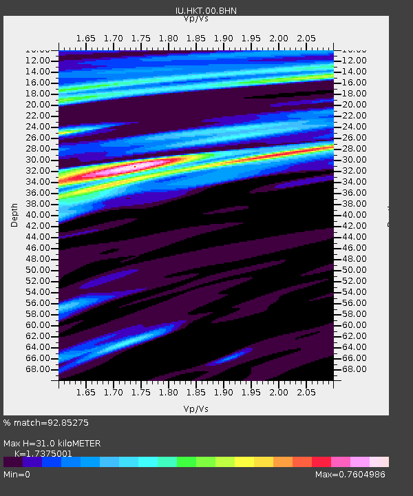
| Estimated Moho Depth: |
31.0 km |
| Estimated Crust Vp/Vs: |
1.74 |
| Assumed Crust Vp: |
5.581 km/s |
| Estimated Crust Vs: |
3.212 km/s |
| Estimated Crust Poisson's Ratio: |
0.25 |
|
| Radial Match: |
92.85275 % |
| Radial Bump: |
342 |
| Transverse Match: |
87.63659 % |
| Transverse Bump: |
400 |
| SOD ConfigId: |
20082 |
| Insert Time: |
2010-03-02 13:50:08.943 +0000 |
| GWidth: |
2.5 |
| Max Bumps: |
400 |
| Tol: |
0.001 |
|
Signal To Noise
| Channel | StoN | STA | LTA |
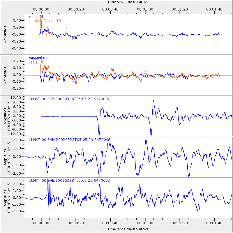
| IU:HKT:00:BHN:20020328T05:05:29.647009Z | 7.564658 | 7.1450154E-7 | 9.445259E-8 |
| IU:HKT:00:BHE:20020328T05:05:29.647009Z | 9.905027 | 8.894365E-7 | 8.9796465E-8 |
| IU:HKT:00:BHZ:20020328T05:05:29.647009Z | 41.932755 | 4.4590747E-6 | 1.0633871E-7 |
| Arrivals |
| Ps | 4.3 SECOND |
| PpPs | 15 SECOND |
| PsPs/PpSs | 19 SECOND |


