You are here: Home > Network List > IU - Global Seismograph Network (GSN - IRIS/USGS) Stations List
> Station HKT Hockley, Texas > Earthquake Result Viewer
HKT Hockley, Texas - Earthquake Result Viewer
| Earthquake location: |
Western Brazil |
| Earthquake latitude/longitude: |
-8.3/-71.7 |
| Earthquake time(UTC): |
2002/10/12 (285) 20:09:11 GMT |
| Earthquake Depth: |
534 km |
| Earthquake Magnitude: |
6.5 MB, 6.9 MW, 6.9 MW |
| Earthquake Catalog/Contributor: |
WHDF/NEIC |
|
| Network: |
IU Global Seismograph Network (GSN - IRIS/USGS) |
| Station: |
HKT Hockley, Texas |
| Lat/Lon: |
29.96 N/95.84 W |
| Elevation: |
-413.0 m |
|
| Distance: |
44.5 deg |
| Az: |
329.655 deg |
| Baz: |
144.819 deg |
| Ray Param: |
0.06928436 |
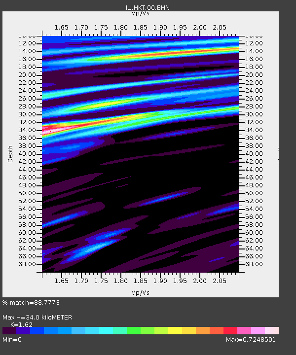
| Estimated Moho Depth: |
34.0 km |
| Estimated Crust Vp/Vs: |
1.62 |
| Assumed Crust Vp: |
5.581 km/s |
| Estimated Crust Vs: |
3.445 km/s |
| Estimated Crust Poisson's Ratio: |
0.19 |
|
| Radial Match: |
88.7773 % |
| Radial Bump: |
288 |
| Transverse Match: |
85.60104 % |
| Transverse Bump: |
400 |
| SOD ConfigId: |
4714 |
| Insert Time: |
2010-03-02 13:50:19.830 +0000 |
| GWidth: |
2.5 |
| Max Bumps: |
400 |
| Tol: |
0.001 |
|
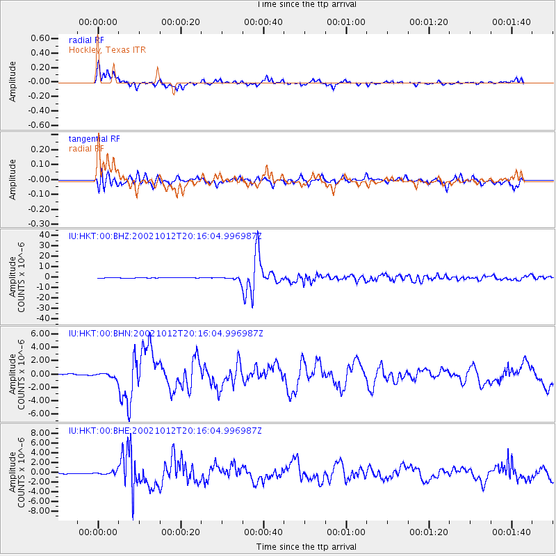
Signal To Noise
| Channel | StoN | STA | LTA |
| IU:HKT:00:BHN:20021012T20:16:04.996987Z | 4.311066 | 3.980346E-7 | 9.232857E-8 |
| IU:HKT:00:BHE:20021012T20:16:04.996987Z | 4.972146 | 3.7069594E-7 | 7.4554514E-8 |
| IU:HKT:00:BHZ:20021012T20:16:04.996987Z | 25.051952 | 2.055916E-6 | 8.20661E-8 |
| Arrivals |
| Ps | 4.0 SECOND |
| PpPs | 15 SECOND |
| PsPs/PpSs | 19 SECOND |


